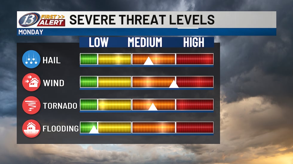
EAU CLAIRE, Wis. (WEAU) – Monday will be a day to be weather aware! As a strengthening low pressure system tracks from the Plains into Minnesota, it will initially carry a warm front through the Upper Midwest during the day, followed by a cold front at night. The warm front will likely produce a round of showers and thunderstorms in the morning hours, with the potential for severe warned hail and gusty winds. This will not be the main event however, as we await the arrival of a cold front into the evening hours. There remains a possibility we see isolated thunderstorms through the afternoon that would quickly turn severe. If any form, they would likely contain large hail and the potential of tornadoes. This is when the greatest threat for a strong tornado will be possible. Otherwise, storms are forecast to develop in Minnesota and organize into a line. These would quickly slide eastward and into Wisconsin, likely after 6pm, with the potential for strong, damaging winds, hail, and embedded tornadoes.
Severe threat levels(weauuuuuuuuuuuuuuuuuuuuuuuuuuuuuuuuuuuuuuuuuuuuuuuuuuuuuuuuuuuuuuuuuuuuuuuuuuuuuuuuuuuuuuuuuuuuuuuuuuuuuuuuuuuuuuuuuuuuuuuuuuuuuuuuuuuuuuuuuuuuuuuuuuuuuuuuuuuuuuuuuuuuuuuuuuuuuuuuuuuuuuuuuuuuuuuuuuuuuuuuuuuuuuuuuuuuuuuuuuuuuuuuuuuuuuuuuuuuuuuuuuuuuuuuuuuuuuuuuuuuuu)
The Storm Prediction Center’s latest convective outlook issued Sunday afternoon continues to keep most of our area in a level 4 of 5 risk. This is primarily due to the risk of strong tornadoes (if they form), while not representing overall coverage of storms.
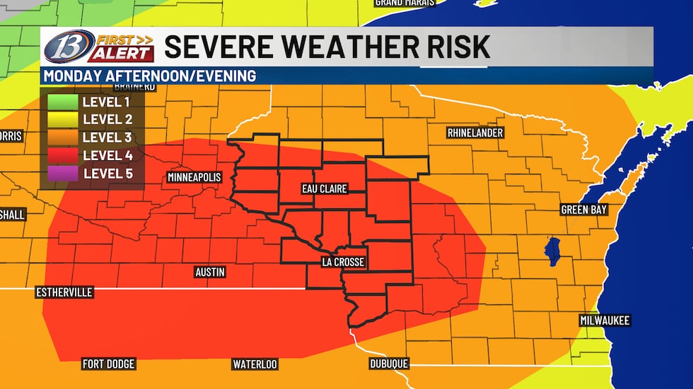
Issued by the SPC as of 12:30 pm Sunday(weau)
This unusually high risk for our part of the country is due to a rare combination of atmospheric ingredients that will be in play. They include significant wind shear, abundant low level moisture, instability and lift generated by these incoming fronts. Timing has to come together with these ingredients to result in the expected severe weather, so it is something we will have to monitor through the day on radar. A First Alert weather day will be in effect and you will be able to get weather information in multiple ways, including our WEAU newscasts, the 13 First Alert weather app, here on the website and on social media. You should already have a plan in place as to where you will go should your location go under a warning. Be sure to have a couple ways to receive those vital alerts and have a solid communication plan with your family.
Copyright 2025 WEAU. All rights reserved.