While severe weather is possible during the day Thursday, most of Green Country won’t see the threat of wind/hail until AFTER the sun comes up. Here is a look at the tornado outlook BEFORE 7am Thursday morning.
Looking back at Wednesday, there were several tornado reports in northern Tulsa County. The NWS has not done an official survey yet, but their preliminary estimate is widespread “high-end EF-1 damage” in the Owasso area.
The Enhanced Fujita Scale is a scale for measuring the intensity of tornadoes after the damage has been done. By examining the damage, surveyors can assign a number from 0 to 5. There were numerous houses in the Owasso area that had severe roof damage or even complete removal of their roof by the tornadic winds. That would be EF-2 damage!
While tornadoes are not expected in Green country before sunrise Thursday, there is a chance of some severe wind/hail during that time, mainly along and south of I-40.
Storms will move into southern Green Country from the Red River Thursday morning and overspread the region throughout the day.
It looks like a wet and wild start to your Thursday. Stay safe on the drive to work and school.
Thursday will bring a chance of showers and gusty t-storms from start to finish.
The afternoon will bring the threat for additional t-storms that could be strong to severe.
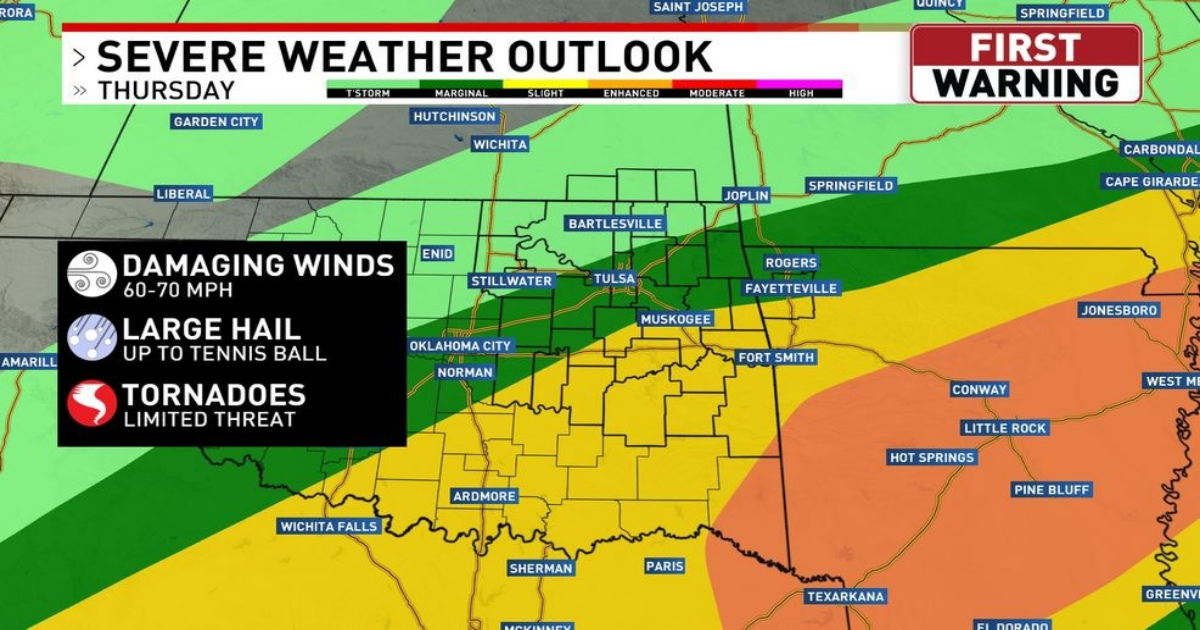
The severe weather outlook for Thursday through Thursday night shows a risk of severe wind/hail for much of Green Country, with the greater threat along and south of I-40, where VERY large hail is possible.
The tornado threat during the day Thursday into Thursday night will be relegated to southeastern Green Country.
The pattern for Friday looks very similar to Thursday, with continued rain/storms and the threat for severe wind/hail throughout the day, especially in southern Green Country.
The next three days will be quite stormy, but the chance of severe wind/hail will diminish greatly on Saturday, which looks to be a chilly, rainy day.
The rain forecast through Saturday night shows much of Green Country can expect several inches of rain. Some spots in southern Green Country could top out over 8 inches of rain!
A Flood Watch has been issued for eastern and southeastern Green Country through Saturday night. You can expect river flooding and even some street flooding with passing drenching t-storms. Turn around! Don’t drown!