No video this morning because of continuing severe weather…
A STORMY START TO SUNDAY
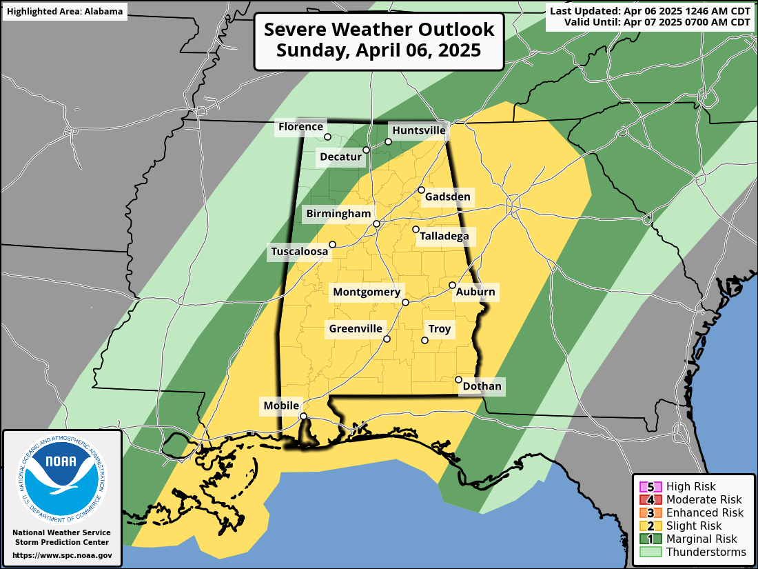
A complex and impactful weather setup continues across Alabama this Sunday morning, with rounds of severe thunderstorms and flash flooding already in progress. A slow-moving line of strong to severe storms is crossing the state, producing damaging winds, heavy rainfall, and isolated tornadoes. Flash flood warnings are in effect across several counties in both north and central Alabama, and conditions will remain active through much of the day.
SEVERE WEATHER AND FLOODING THREAT
The SPC maintains a slight risk (level 2 of 5) for severe storms across Alabama today, including the risk of damaging winds, hail, and isolated tornadoes. A Flood Watch remains in effect for nearly all of Central and North Alabama through this evening. A tornado watch is in effect for all of Central Alabama until 10 a.m. The main concerns are damaging wind gusts along the line of storms, the potential for a few spin-up tornadoes within the QLCS structure, and localized flash flooding. Rainfall totals of 3 to 4 inches are likely in many areas, particularly between the I-20 and I-85 corridors, with localized amounts up to 6 inches where storms train repeatedly over the same locations.
THE SETUP
This storm system is driven by a combination of strong jet stream support aloft and an unusually warm and moist airmass at the surface. While the main upper-level energy is still well to the west, it is contributing to an unstable environment with CAPE values over 1000 J/kg and effective shear values supportive of embedded supercells.
SUNDAY’S WEATHER
Storms will continue throughout the morning hours, gradually pushing eastward across the state. Central Alabama will experience the most widespread activity between 5 a.m. and 2 p.m. Behind the main line, scattered showers and a few rumbles of thunder will persist into the afternoon, but the severe risk will diminish over time. Areas hardest hit by rainfall earlier in the day may see renewed flash flooding during the afternoon due to slow storm movement and saturated soils.
SUNDAY NIGHT OUTLOOK
Rain chances begin to taper off from west to east overnight Sunday into Monday morning. Cooler, drier air will begin to move into the state, setting the stage for a much calmer start to the new workweek. Skies will gradually clear, but some lingering clouds and patchy drizzle could remain in eastern areas before sunrise Monday.
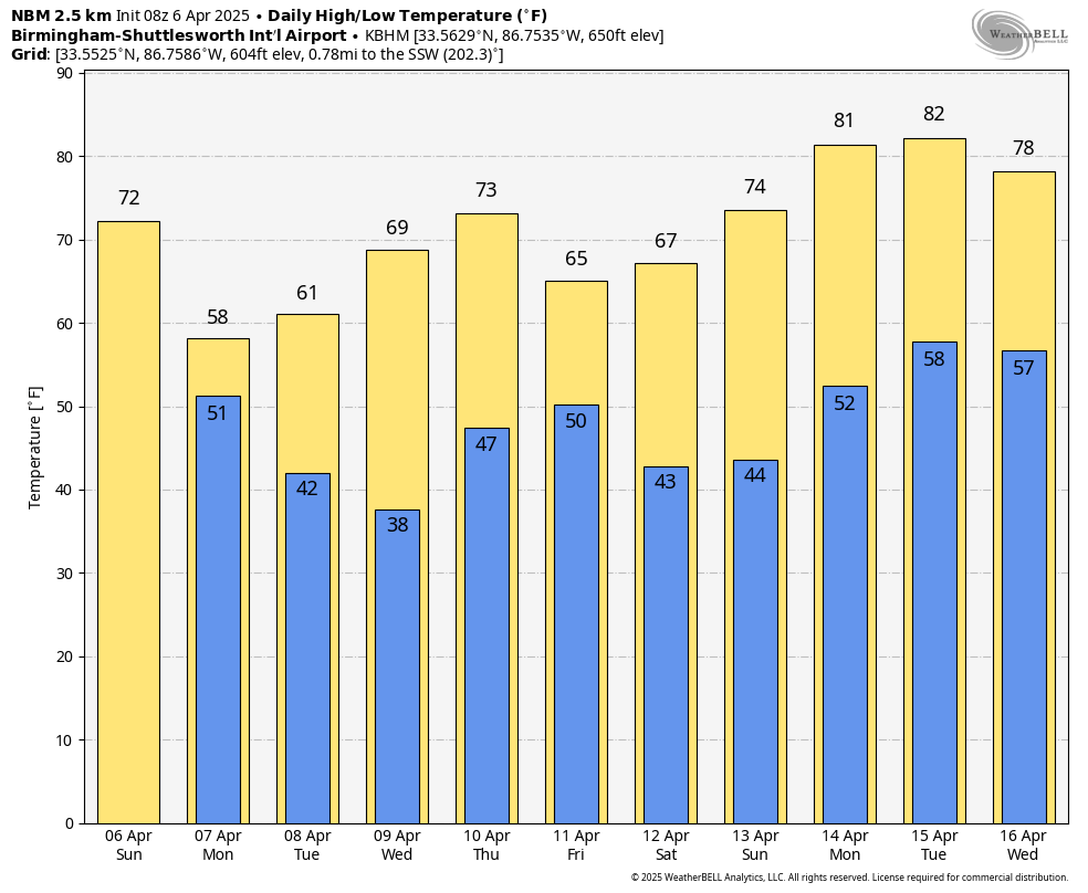
TURNING COLDER MONDAY
Temperatures will be noticeably cooler on Monday, with highs struggling to reach the upper 50s in many locations under mostly cloudy skies. A few lingering showers are possible early, but most of the day will be dry as northwesterly winds take hold. The cooler air is the leading edge of a pattern shift that will bring chilly mornings for much of the upcoming week.
COLD WEATHER AND FROST CONCERNS
Widespread frost and freeze conditions are expected Tuesday morning, especially in the northern half of Alabama. By Wednesday morning, freezing temperatures may reach as far south as central portions of the state. Sensitive plants and vegetation may be at risk, so residents should prepare accordingly. Highs will remain well below normal both Tuesday and Wednesday, with most areas staying in the 50s and 60s.
LATE WEEK RAIN AND STORMS
A new cold front will approach Alabama late Thursday into Friday, bringing another chance of showers and possibly a thunderstorm. However, the best dynamics with this system remain to the north, so severe weather is not expected at this time. The rain should move out quickly, and dry air will return behind the front just in time for the weekend.
FINE WEEKEND WEATHER AHEAD
If you’re making outdoor plans next weekend, you’re in luck. Saturday is shaping up to be sunny and pleasant, with highs in the upper 60s to lower 70s. Overnight lows will be cool but not as cold as earlier in the week. Overall, a welcome stretch of calm weather is expected following this active period.
BEACH FORECAST
Along the Alabama and Florida Gulf Coasts, rough surf and dangerous rip currents continue today through Monday. A high rip current risk and high surf advisory are in effect, with waves reaching 4 to 6 feet. Showers and thunderstorms are likely today and Monday, with highs in the upper 70s today and mid 60s Monday. Conditions will improve by Tuesday, with sunnier skies, lighter winds, and falling surf heights. Water temperatures are in the middle 70s.
WEATHERBRAINS NOTE
On the next episode of WeatherBrains, we’ll talk about how budget cuts are impacting the National Weather Service and NOAA, with a panel of experts including Tom Skilling, Dr. Louis Uccellini, Dr. Don Wuebbles, Dr. Victor Gensini, and Paul Daly. Don’t miss this important conversation about the future of weather forecasting and public safety.
ON THIS DATE IN 2005
On the next episode of WeatherBrains, our guest will be author and disaster preparedness expert Ron Foster, who writes about survival in extreme weather scenarios such as hurricanes and solar flares. Joining us as a special guest panelist is climatologist Jared Rennie from the National Centers for Environmental Information, who will help connect real-world climate data to the scenarios Ron explores in his work. It’s sure to be a fascinating and thought-provoking discussion.
Category: Alabama’s Weather, ALL POSTS, Severe Weather, Social Media
Page 2
 A powerful storm system brings severe weather and flooding to Alabama today, followed by a sharp cooldown and the potential for frost by midweek.
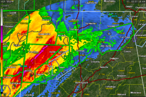
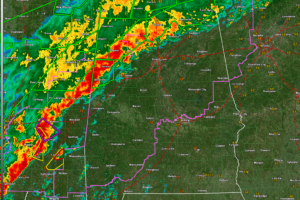 Flash flooding is widespread across northern Alabama, and a line of storms moving in from Mississippi will continue to pose a threat of damaging winds and brief tornadoes through the morning.
 Flash flood warnings remain in effect early this morning for parts of north and central Alabama, where multiple rounds of heavy rain have led to dangerous flooding in low-lying and poor drainage areas.
 The tornado watch goes until 10 am.
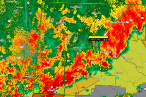
 Severe thunderstorms were located along a line extending from near Henagar to near Geraldine to near Strawberry, moving east at 20 mph.
 Doppler radar indicated thunderstorms producing heavy rain across the warned area. Between 1.5 and 2.5 inches of rain have fallen. Additional rainfall amounts of 1 to 2 inches are possible in the warned area. Flash flooding is ongoing or expected to begin shortly.
 This dangerous storm will be near…Sylvania, Powell, and Rainsville around 205 AM CDT. Fort Payne around 210 AM CDT.
 Dangerous storm coming out of Pickens County, but the radar data is messy and doesn’t seem to indicate that there is a tornado there.
 severe thunderstorms were located along a line extending from near Trenton to near Ider to near Pisgah, moving east at 50 mph.
 Severe thunderstorms were located along a line extending from 8 miles west of Arab to near Moreland, moving east at 25 mph.
 Folks from Macedonia to Ethelsville, all along US-82 then up to Liberty, Shaw, and Bethlehem need to be in tehir tornado safe spots now!
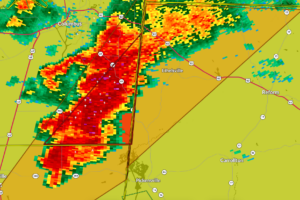 A severe storm with rotation aloft is moving into Pickens County, prompting a warning through 2:15 AM as we watch closely for potential tornado development.
 The most dangerous storm is near New Hope in southern Madison County moving east southeast into Marshall County approaching Lake Guntersville.
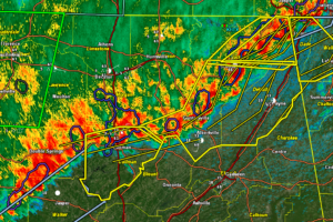
 Two rotations over eastern Mississippi and western Alabama have us concerned at this hour.
