by Joe Charlevoix
Fri, February 28th 2025 at 7:58 PM
WPBN Default.png
The next round of accumulating snow will arrive late tonight into Friday for parts (but not all) of Northern Michigan transitioning to lake effect into Friday night into part of Saturday. Heaviest snow totals will fall across the Eastern U.P./Straits region. Significantly colder Saturday but it won’t linger as milder temperatures return early next week.
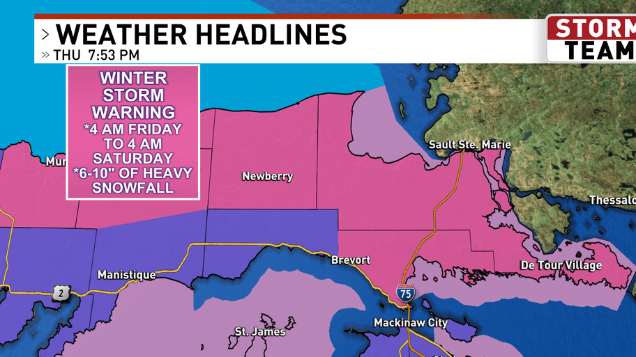
WINTER STORM WARNINGS are in effect for parts of the Eastern U.P. including Newberry and Sault Ste. Marie with WINTER WEATHER ADVISORIES for parts of the Eastern U.P. and Straits region including Naubinway, Petoskey and Cheboygan.
FRIDAY (FEB 28): A more potent clipper drops out of Canada late Thursday into Friday with snow overspreading most of Northern Michigan Friday morning. The heaviest snow will fall across the Eastern U.P. where 6-12″ is possible Friday through early Saturday. The amounts drop as one heads south into the Lower Peninsula with 2-6″ north of a Charlevoix-Gaylord-Alpena line and an inch or less south of there. By the afternoon we may see some rain mixing in or switching completely over to rain for a time and in parts of the Northern/Central Lower Peninsula it could be dry with a few peeks of sunshine Friday afternoon for a time. Highs will range from the 20’s north to 40’s south. South to NW wind 20-30 mph with gusts to 40 mph expect a SE to NE wind across the Eastern U.P.
SATURDAY (MAR 1): Significantly colder Saturday with ongoing lake effect snow expected for some spots. In particular lake effect snow will hang on near Lake Michigan from the Leelanau Peninsula south including areas around Grand Traverse Bay and Frankfort/Manistee/Ludington as well as across the U.P. in areas along/west of Interstate-75. Elsewhere mostly cloudy. Daytime highs will only reach 14-20F. NNW wind 15-20 with a few higher gusts.
SUNDAY (MAR 2): Quiet and a tad warmer compared to Saturday. Maybe a few flurries but a partly/mostly cloudy sky is in the forecast overall. High temperatures will reach 25-28F.
EXTENDED FORECAST: Longer range weather model guidance suggests a deepening storm system in the heart of the country Monday will lift toward the area in the Tuesday/Wednesday/Thursday timeframe with what could be rain or a wintry mix turning back over to snow.
-Meteorologist Joe Charlevoix