The risk for severe storms will increase over western and central Iowa this evening.Here’s what we know about Thursday’s system: Strong to severe thunderstorms expected to develop this evening Very large hail is possible which can lead to property damage Severe Thunderstorm Watch until 10pmA Severe Thunderstorm Watch has been issued for portions of northern and northwestern Iowa through 10pm. Storms are expected to develop over the next few hours bringing a risk for large hail.Where and when storms will fireSevere thunderstorms are expected to develop between 4 and 6pm over portions of eastern Nebraska into western Iowa with the risk for very large hail. A severe weather watch is expected to be issued for western Iowa by early this evening.An Enhanced Risk for severe weather, or a 3 of 5 chance is present over western and central Iowa. The rest of our area will have a Level 2 of 5 risk for severe storms Thursday evening through the early overnight. The greatest risk will be large to very large hail, with some potential for hail large than 2 inches in diameter.Warm and humid air in place this afternoon will lead to an increasing chance for thunderstorms this evening as a cold front pushes into the state from the west. Storms will initially develop in northwest and far western Iowa by 4 to 5pm.Storms will move into central Iowa, reaching the Des Moines metro and the I-35 corridor between 8 and 10pm. Storms will likely begin to weaken as they move into cetnral Iowa, but the risk for large hail will continue as storms approach the metro.The highest severe weather risk will be along and north of the I-80 corridor. Storm coverage is expected to decrease heading south into southern Iowa. The severe risk will largely end by Midnight for most of the state. Storms should be weakening significantly by Midnight and moving out of the state by 2 to 4am. What threats to expectLarge hail is the main threat expected with Thursday evening’s storms — especially for the western 2/3rds of the state. Hail up to or potentially even larger than 2 inches in diameter will be possible with the strongest storms. Hail this large can produce significant property damage, and injuries to anyone caught outdoors.Tornado and damaging wind potential will be more limited, but a tornado still cannot be ruled out, especially over western Iowa as storms initially develop this evening.A few spots could get meaningful rain, but widespread, heavy downpours don’t look likely right now. How to submit storm photos to KCCIHave photos or videos of lightning, hail or any other storm damage from Thursday’s severe weather?You can share it with us here or by emailing [email protected] to make sure your phone gets severe weather alertsWhen storms are in the forecast, you want to make sure your mobile phone settings allow for alerts that warn you of severe weather. The U.S. Homeland Security Department says to check your phone’s settings and ensure you have “Government Alerts” or “Emergency Alert Messages” enabled.You can also keep track of the weather wherever you are with the KCCI app: Apple | Google PlayWe’ll send you weather alerts and you can track live radar right on your phone.Keep an eye on weather across Iowa with KCCI’s skycamsWeather watchers can keep an eye on conditions by checking our skycam page, which shows aerial views from a dozen sites across the state.» Subscribe to KCCI’s YouTube page» Download the free KCCI app to get updates on the go: Apple | Google Play
DES MOINES, Iowa —The risk for severe storms will increase over western and central Iowa this evening.
Here’s what we know about Thursday’s system:
- Strong to severe thunderstorms expected to develop this evening
- Very large hail is possible which can lead to property damage
Severe Thunderstorm Watch until 10pm
A Severe Thunderstorm Watch has been issued for portions of northern and northwestern Iowa through 10pm. Storms are expected to develop over the next few hours bringing a risk for large hail.

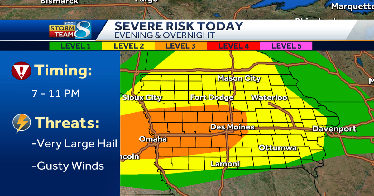
Where and when storms will fire
Severe thunderstorms are expected to develop between 4 and 6pm over portions of eastern Nebraska into western Iowa with the risk for very large hail. A severe weather watch is expected to be issued for western Iowa by early this evening.

An Enhanced Risk for severe weather, or a 3 of 5 chance is present over western and central Iowa. The rest of our area will have a Level 2 of 5 risk for severe storms Thursday evening through the early overnight. The greatest risk will be large to very large hail, with some potential for hail large than 2 inches in diameter.

Warm and humid air in place this afternoon will lead to an increasing chance for thunderstorms this evening as a cold front pushes into the state from the west. Storms will initially develop in northwest and far western Iowa by 4 to 5pm.

Storms will move into central Iowa, reaching the Des Moines metro and the I-35 corridor between 8 and 10pm. Storms will likely begin to weaken as they move into cetnral Iowa, but the risk for large hail will continue as storms approach the metro.
The highest severe weather risk will be along and north of the I-80 corridor. Storm coverage is expected to decrease heading south into southern Iowa. The severe risk will largely end by Midnight for most of the state. Storms should be weakening significantly by Midnight and moving out of the state by 2 to 4am.
What threats to expect
Large hail is the main threat expected with Thursday evening’s storms — especially for the western 2/3rds of the state. Hail up to or potentially even larger than 2 inches in diameter will be possible with the strongest storms. Hail this large can produce significant property damage, and injuries to anyone caught outdoors.

Tornado and damaging wind potential will be more limited, but a tornado still cannot be ruled out, especially over western Iowa as storms initially develop this evening.
A few spots could get meaningful rain, but widespread, heavy downpours don’t look likely right now.
Have photos or videos of lightning, hail or any other storm damage from Thursday’s severe weather?
You can share it with us here or by emailing [email protected].
How to make sure your phone gets severe weather alerts
When storms are in the forecast, you want to make sure your mobile phone settings allow for alerts that warn you of severe weather. The U.S. Homeland Security Department says to check your phone’s settings and ensure you have “Government Alerts” or “Emergency Alert Messages” enabled.
You can also keep track of the weather wherever you are with the KCCI app: Apple | Google Play
We’ll send you weather alerts and you can track live radar right on your phone.
Keep an eye on weather across Iowa with KCCI’s skycams
Weather watchers can keep an eye on conditions by checking our skycam page, which shows aerial views from a dozen sites across the state.
» Subscribe to KCCI’s YouTube page
» Download the free KCCI app to get updates on the go: Apple | Google Play