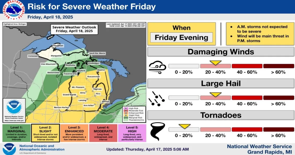
- Severe thunderstorms are possible in Michigan’s Lower Peninsula on April 18, with damaging winds, hail, and isolated tornadoes as potential threats.
- Temperatures are expected to reach near 80 degrees in southern Michigan before the storms arrive, bringing cooler temperatures for the weekend.
- The Upper Peninsula is expected to experience rain and snow, but severe weather is not anticipated.
Much of the Lower Peninsula could see thunderstorms and severe weather on April 18, the National Weather Service is warning.
“Thunderstorms will be possible first thing in the morning, and then again late in the afternoon and evening on Friday. Severe weather is possible, with damaging winds the main threat. Some large hail will be possible, and an isolated tornado is also possible,” the weather service said.
Storms could produce damaging winds and large hail; tornadoes, and short-lived, possibly widespread or isolated storms, the weather service said on April 17.
The storms will result from a cold front moving across the state. Temperatures could rise to near 80 degrees in southern Michigan Friday before storms move in and lower temperatures.
The Detroit area could see a high of 78 April 18, but temperatures will only be in the upper 60s on April 19. Easter Sunday will be in the upper 50s with rain showers. In west Michigan, including Grand Rapids, temperatures will be about 77 on April 18 before falling into the 50s on April 19. Easter Sunday will be in the upper 50s.
In northern Michigan, including Gaylord, temperatures on April 18 will be in the upper 60s before falling into the 40s Saturday and Sunday. In Sault Ste. Marie, the high on April 18 will be about 50 degrees before dropping into the 40s for the weekend.
A hazardous weather outlook is in effect for residents in the Lower Peninsula, from Alpena to south. An outlook is intended to create awareness before severe weather in case watches or warnings are issued that require shelter or evacuation. Small craft advisories are in place for lakes Michigan, Huron and Superior.
“Stay informed on developments in the latest forecast updates today through Friday,” the NWS in Detroit said on X.
Weather officials said the Lower Peninsula from Grand Traverse Bay to Alpena and all areas south have a slight risk for severe weather. Farther north the risk south of the Straits of Mackinac is “marginal.” There is no threat of severe weather in the UP.
Here’s more on the upcoming forecast:
When will storms start on April 18?
In Grand Rapids, rain showers and thunderstorms are expected to start after 5 a.m. April 18, with gusts reaching 29 mph, and rainfall amounting to a tenth and a quarter of an inch.
“A few non-severe storms are expected early Friday morning. Additional storms will develop Friday evening. The evening storms could become severe with damaging winds the main threat,” the Grand Rapids NWS said on X.
Severe thunderstorms will be move in during the afternoon on April 18, with gusts up to 31 mph. Storms are expected to calm April 19.
In the Lansing area, officials predict rain to begin after 5 a.m. Friday morning. Throughout the day, there will be gusts up to at 31 mph with rain totaling less than a tenth of an inch. Higher amounts could be recorded in some areas.
Southeast Michigan residents can expect rain to begin after 2 a.m. Friday. As the weather continues, gusts could reach up to 26 mph with rain of at least a tenth of an inch.
“Linear clusters of storms are expected along a cold front moving in from the Midwest late in the day and Friday night,” the NWS Detroit office said on X.
The Alpena area is expected to see rain begin after midnight April 17, lasting through Friday then calming down on Saturday.
“Isolated to scattered severe thunderstorms are possible on Friday, best chance along/south of M-32,” the Gaylord NWS office said.
Where are storms expected to hit Michigan?
The NWS is expecting storms hit lower Michigan cities the hardest. Rain will fall in the Upper Peninsula, but severe weather isn’t expected.
“Widespread rainfall is expected late Thursday into Friday evening. Rain and snowmelt will lead to rises on area rivers and possible minor flooding on typically flood-prone rivers,” the NWS in Marquette said on X on April 15.
In Marquette, rain is expected to begin before 3 a.m. April 18 and last through the day, with chances of rain transitioning into snow. Gusts are expected at 20-30 mph.
The NWS in Marquette said the UP will see showers starting April 17 overnight and tapering off by April 19.
What should I prepare for severe weather?
The NWS has a severe weather checklist before storms become severe, here’s what officials suggest:
- Check the Hazardous Weather Outlook.The Hazardous Weather Outlook (HWO) can tell you when thunderstorms are expected to hit near you, where the best chance of severe weather will be, and what will be the primary severe weather hazards.
- Check Your Kit:If you have a severe weather safety kit and/or NOAA All-Hazards Radio, you should make sure that everything has fresh batteries that work. You should check your radio, flashlight, etc. because they may become necessary later in the day. Make sure your cell phone is fully charged in case you lose power. If you don’t have a severe weather safety kit, here are some suggestions to get you started.
- Review Your Safety Plan:If you have a severe weather safety plan you should review it. Make sure everyone in your family knows what to do in certain situations. Know where everyone will be during the day and make it clear what to do if severe weather impacts your location. Know where to seek shelter beforehand! If you don’t have a tornado safety plan, review some safety tips and suggestions.
- Find A Way To Monitor Weather Information:Whether it be via a television, AM/FM radio, social media, NOAA All-Hazards Radio, etc., continue to monitor weather information during the day for any changes in the situation. Set up a routine (i.e. check the weather information every hour on the hour).
Contact Sarah Moore @ [email protected]