The first round of thunderstorms is expected to develop late Sunday night in the eastern Dakotas and western Minnesota, moving east-northeast toward dawn. Stronger waves of severe weather are likely to form Monday afternoon into the evening, with a risk of powerful tornadoes.
Storms begin late Sunday night
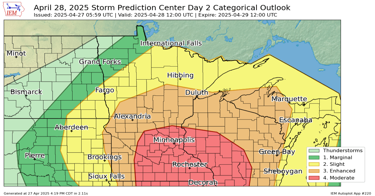
All of our attention is now turning to the latest weather system and the threat of severe weather it brings to the Upper Midwest.
The Storm Prediction Center has issued a level 4 out of 5 moderate risk for areas including the Twin Cities, St. Cloud, Wilmar, New Ulm and all of southeastern Minnesota. Areas outside of the moderate risk area still have an enhanced risk (3 out of 5), and should not be overlooked.
MPR News helps you turn down the noise and build shared understanding. Turn up your support for this public resource and keep trusted journalism accessible to all.

Severe weather threat for Monday
Iowa Environmental Mesonet- Iowa State University
Overnight into early Monday morning we will see the main threat of large hail and damaging winds as storms spread across central Minnesota towards northern Wisconsin.

Forecast precipitation Sunday 7 p.m. to Monday 10 a.m.
NOAA via Tropical Tidbits
A lull is expected between the early morning storms and the redevelopment in the afternoon. During this period, the atmosphere will have ample time to recharge. Dewpoints will surge into the 60s, strong southerly winds will bring in warm air, and plenty of shear (directional wind change) will create the conditions for powerful supercells.

Dewpoints Sunday 7 p.m. to Monday 7 p.m.
NOAA via College of DuPage Weather
Once the storms ignite they could develop into a line of storms, in which case damaging winds, very large hail and tornadoes are possible. If we get smaller, cluster-like storms, they will have the potential for strong, long-lived tornadoes.

Forecast precipitation Monday 1 p.m. to midnight
NOAA via Pivotal Weather
The period between 2 PM and 9 PM will be critical to monitor the weather closely. Be sure to have a plan in place in case warnings are issued.
As always, we will keep you up to date on the Updraft blog and on MPR News.