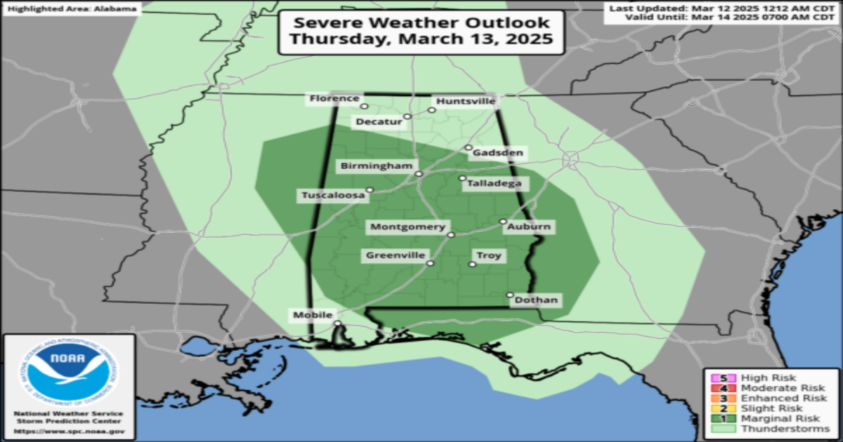
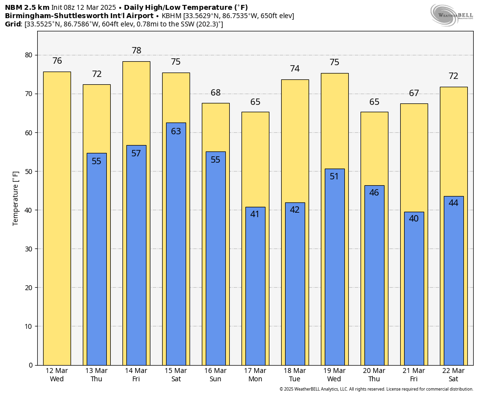
ONE MORE DRY DAY: With a partly to mostly sunny sky today, we project a high in the 75-80 degree range this afternoon. Clouds will increase tonight, and a few showers and thunderstorms are likely tomorrow. SPC maintains a low end “marginal risk” of severe thunderstorms across much of the state tomorrow.

A few of the heavier storms could produce strong wind gusts and small hail, but dynamics are weak and the overall severe weather threat is low.
Much of the day Friday will be dry; it will be warm and breezy with a high in the 76-82 degree range.
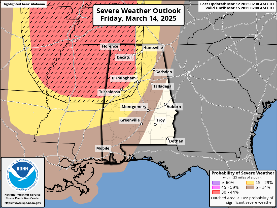
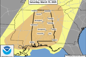
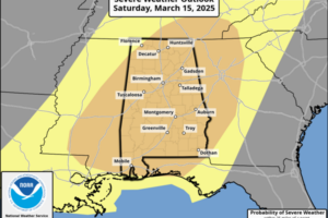
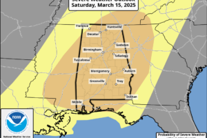
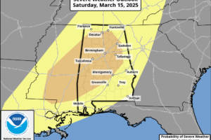
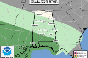
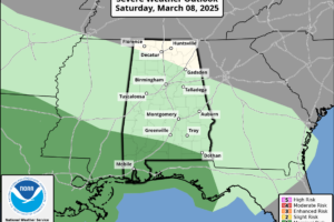
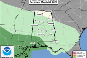
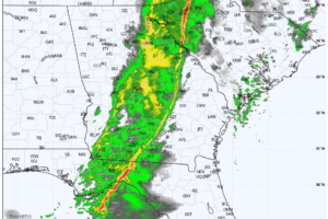
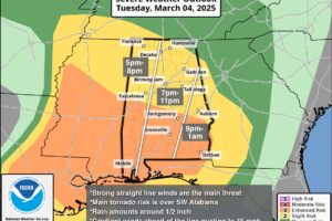
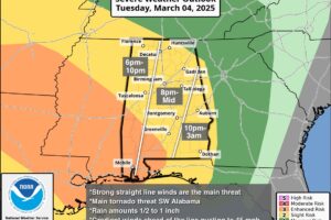
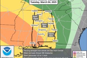
SIGNIFICANT SEVERE WEATHER THREAT: A high end severe weather risk is setting up for Alabama in the broad window from 9pm Friday through 6am Sunday. All of Alabama is in an “enhanced risk” as defined by SPC, NOAA’s Storm Prediction Center. There will be two primary rounds of thunderstorms.
FRIDAY NIGHT/SATURDAY MORNING: The first batch of storms associated with this very dynamic storm system will move into Northwest Alabama Friday night. These storms will continue into Saturday morning over the northern half of the state; hail and damaging winds are possible along with an isolated tornado or two.
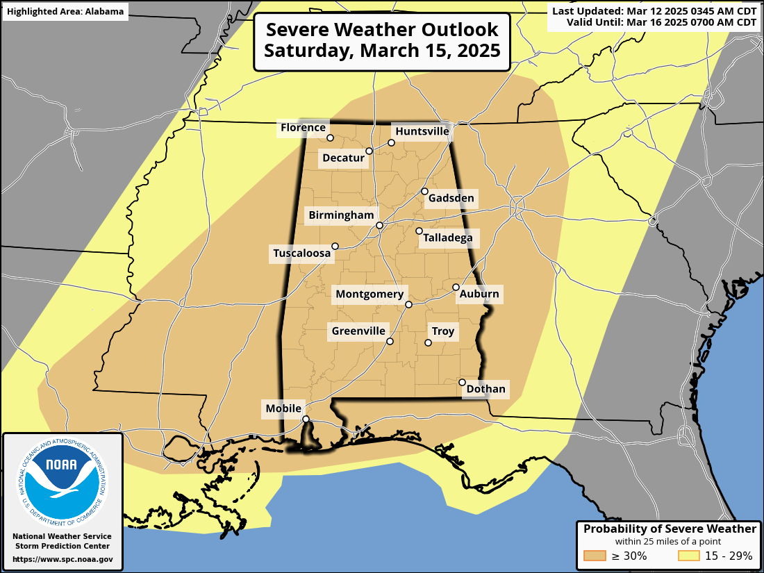
SATURDAY AFTERNOON/SATURDAY NIGHT: This will likely be the “main show”. Storms will be capable of producing large hail, damaging winds, and tornadoes. Based on forecast parameters, a few strong tornadoes will be possible (EF-2 or higher). These storms should be out of the state by daybreak Sunday.
A few important notes…
*It is helpful to look and see what an atmospheric setup like this has produced in the past. Some of the analogs that are showing up include April 8, 1998, December 16, 2000, and November 24, 2001. These days all featured numerous severe thunderstorms including some very significant tornadoes.
*April 27, 2011 is NOT an analog for this event. That is generational… days like that tend to happen every 40 years or so.
*We have to walk a very fine line between introducing fear and describing the potential for a high end weather event. For those that have weather anxiety, just remember than even during high end severe weather events, odds of any spot being hit by a tornado are relatively low. But stronger wording is appropriate for this type of threat.
*Our goal for any severe weather event in Alabama is no loss of life, and no serious injuries. It takes us all working together to make that happen. The most important part of preparedness is to be sure you have a reliable way of hearing warnings. Never, ever an outdoor siren. Never. A NOAA Weather Radio should be in every Alabama home and business. On your phone, have WEA enabled (Wireless Emergency Alerts), and have the 33/40 weather app installed.
*Be sure and subscribe to the James Spann and ABC 33/40 YouTube channels so you watch live severe thunderstorm/tornado coverage.
youtube.com/jamesspann
youtube.com/abc3340
*In your safe place, have helmets for everyone, including adults. Most serious injuries in tornadoes involve blunt force trauma above the shoulders.
*If you live in a mobile home, know the location of the nearest shelter, or business open 24/7 that can serve as a shelter. Have transportation arranged so you can get there quickly.
*If you are reading this, you pay attention to weather. Understand many people don’t keep up with the weather, so you can be a hero during the severe weather event. If you have a friend or loved one in a tornado warning polygon, be sure and call or text them to let them know of the immediate danger. Let them know now that severe storms are likely late Friday night through early Sunday morning.
*Soon we will be within the 60 hour window, when high resolution model data will be available. This is when we can be more specific about timing and the event in general.
Look for a clearing sky Sunday with a high in the upper 60s and low 70s.
NEXT WEEK: Much of the week will be dry and mild, but we will mention a chance of showers and thunderstorms Wednesday with a surface front passing through. For now this doesn’t look like a severe weather setup… See the video briefing for maps, graphics, and more details.
ON THIS DATE IN 1993: The generational “Blizzard of 93” was underway. All 67 Alabama counties had measurable snow; winds gusted to nearly hurricane force on ridges with white out conditions, snow amounts of 1 to 2 feet were common over the northern half of the state, with drifts to 4 feet. There was a lot of eerie green lightning followed by the muffled sound of thunder during the peak of the storm. With the atmosphere overloaded with big snowflakes, part of the sound of thunder was absorbed.
Some had no power for over a week. We forecast 6 to 16 inches of snow going into the event, but many didn’t listen since it was mid-March, the flowers were blooming, and the high on March 10, 1993 (two days before the blizzard) was 75.
The storm dropped 13 inches at the Birmingham International Airport, where the records are kept, and almost two feet of snow across parts of southern Jefferson and northern Shelby counties. The heaviest snow across the Southeast U.S. was recorded was at Newfound Gap, where U.S. 441 crosses the Tennessee and North Carolina border, with five feet.
Look for the next video briefing here by 3:00 this afternoon… enjoy the day!
Category: Alabama’s Weather, ALL POSTS, Weather Xtreme Videos
Page 2
 ONE MORE DRY DAY: With a partly to mostly sunny sky today, we project a high in the 75-80 degree range this afternoon. Clouds will increase tonight, and a few showers and thunderstorms are likely tomorrow.
 BLUE SKY: We have a cloudless sky across Alabama this afternoon with temperatures in the 70s. Tonight will be clear and cool with a low in the 46-54 degree range.
 NICE WARM-UP TODAY: Colder spots are in the mid 30s across North Alabama early this morning, but we expect a high in the 70s statewide today with a good supply of sunshine. No change tomorrow; dry and mild with highs in the 70s.
 IMPROVING WEATHER: The sky has becoming sunny across the northern 2/3 of Alabama this afternoon as dry air returns; clouds over the southern counties will move out this evening. Tonight will be mostly clear with a low in the 40s. We might see a few spots over North Alabama in the upper 30s.
 RADAR CHECK: We have large areas of rain across parts of Alabama this morning; the rain should be out of the state completely by early afternoon, followed by gradual clearing. Temperatures will rise into the low to mid 60s this afternoon.
 PLEASANT MARCH AFTERNOON: Temperatures are in the 65-72 degree range across Alabama this afternoon with a partly to mostly sunny sky. Clouds will increase tonight, and a few spotty showers are possible as moisture levels rise.
 STILL DRY TODAY: After a chilly start early this morning with temperatures in the 30s in many areas, we are forecasting a high in the 67-73 degree range this afternoon with a partly sunny sky. Clouds will increase tonight, and a few spotty showers are possible as moisture levels begin to rise.
 BLUE SKY: With a cloudless sky temperatures are in the 50s over North Alabama, with low to mid 60s for the southern counties. Tonight will be clear with a low in the 33-43 degree range.
 CHILLY START: Some of the colder spots across North Alabama have dropped into the low 30s early this morning.. we expect a high in the 50s across North Alabama today with a sunny sky; South Alabama will rise into the low 60s. Tomorrow will be warmer with 60s statewide as the sky will remain mostly sunny.
 WINDY, COLD MARCH DAY: Clouds cover the northern half of Alabama this afternoon… temperatures are only in the mid to upper 40s with a gusty west wind making it feel colder. However, to the south, temperatures are in the 60s for places like Mobile and Dothan where the sun is out in full force. We will mention the chance of a few sprinkles over North Alabama this evening as a deep upper trough passes through
 DRIER DAY: Rain has pushed out of Alabama early this morning; we will be dry through early afternoon with a gusty west wind; a wind advisory remains in effect for much of the state. Gradient winds won’t be a strong as yesterday, but gusts to 30 mph are very possible.
 WINDY: As advertised, gradient winds have ramped up across Alabama; gusts are in the 30-40 mph range for most communities. Montgomery reports a gust to 44 mph at mid-afternoon. We have a mix of sun and clouds, but a line of showers and storms will move into West Alabama by 5-6 p.m.
 BECOMING WINDY: A wind advisory goes into effect for all 67 Alabama counties this afternoon, and will continue through tomorrow morning. A deepening surface low will set up a tight pressure gradient across much of the central and southern U.S. over the next 24 hours
 SUNNY MARCH DAY: With sunshine in full supply temperatures are in the 60s across Alabama this afternoon. Tonight will be fair and cool with a low in the 40s.