From James Spann and the ABC 33/40 Weather Blog:
ONE MORE DRY DAY: With a partly to mostly sunny sky today, we project a high in the 75-80 degree range this afternoon. Clouds will increase tonight, and a few showers and thunderstorms are likely tomorrow. SPC maintains a low end “marginal risk” of severe thunderstorms across much of the state tomorrow.
A few of the heavier storms could produce strong wind gusts and small hail, but dynamics are weak and the overall severe weather threat is low.
Much of the day Friday will be dry; it will be warm and breezy with a high in the 76-82 degree range.
SIGNIFICANT SEVERE WEATHER THREAT:
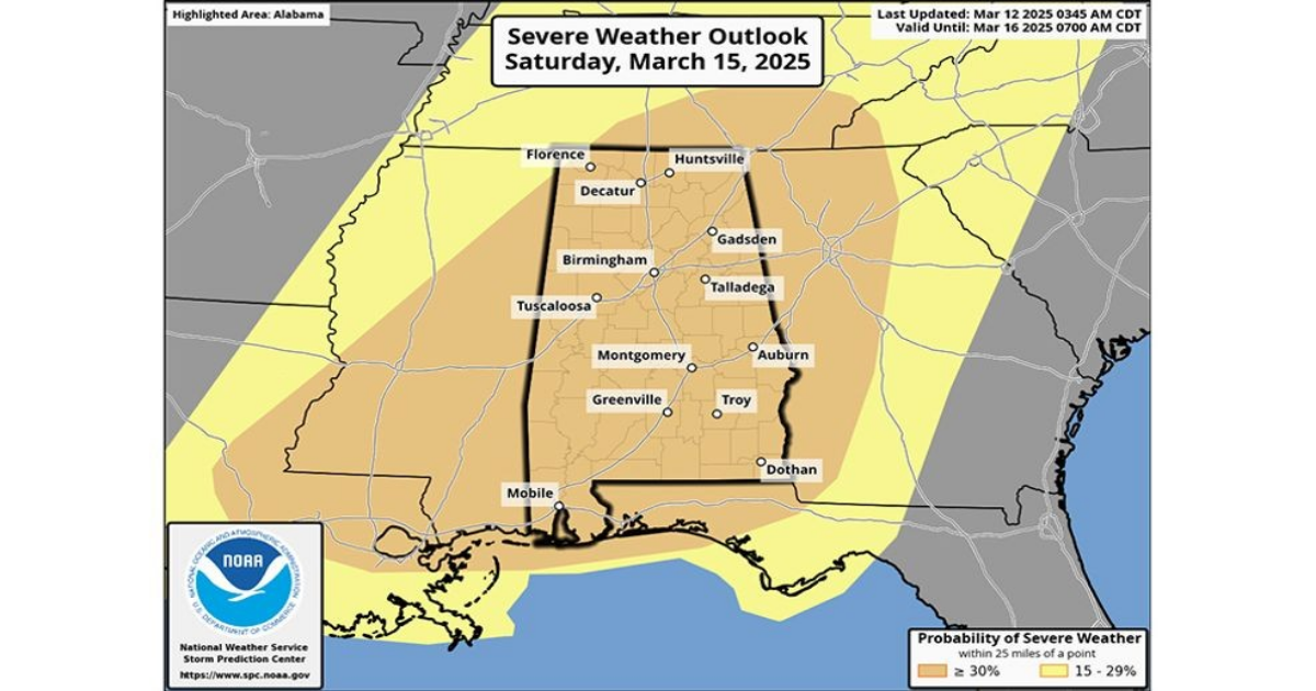
A high end severe weather risk is setting up for Alabama in the broad window from 9pm Friday through 6am Sunday. All of Alabama is in an “enhanced risk” as defined by SPC, NOAA’s Storm Prediction Center. There will be two primary rounds of thunderstorms.
FRIDAY NIGHT/SATURDAY MORNING: The first batch of storms associated with this very dynamic storm system will move into Northwest Alabama Friday night. These storms will continue into Saturday morning over the northern half of the state; hail and damaging winds are possible along with an isolated tornado or two.
SATURDAY AFTERNOON/SATURDAY NIGHT: This will likely be the “main show”. Storms will be capable of producing large hail, damaging winds, and tornadoes. Based on forecast parameters, a few strong tornadoes will be possible (EF-2 or higher). These storms should be out of the state by daybreak Sunday.
A few important notes
*It is helpful to look and see what an atmospheric setup like this has produced in the past. Some of the analogs that are showing up include April 8, 1998, December 16, 2000, and November 24, 2001. These days all featured numerous severe thunderstorms including some very significant tornadoes.
*April 27, 2011 is NOT an analog for this event. That is generational days like that tend to happen every 40 years or so.
*We have to walk a very fine line between introducing fear and describing the potential for a high end weather event. For those that have weather anxiety, just remember than even during high end severe weather events, odds of any spot being hit by a tornado are relatively low. But stronger wording is appropriate for this type of threat.
*Our goal for any severe weather event in Alabama is no loss of life, and no serious injuries. It takes us all working together to make that happen. The most important part of preparedness is to be sure you have a reliable way of hearing warnings. Never, ever an outdoor siren. Never. A NOAA Weather Radio should be in every Alabama home and business. On your phone, have WEA enabled (Wireless Emergency Alerts), and have the 33/40 weather app installed.
*Be sure and subscribe to the James Spann and ABC 33/40 YouTube channels so you watch live severe thunderstorm/tornado coverage.
http://youtube.com/abc3340 and http://youtube.com/jamesspann
*In your safe place, have helmets for everyone, including adults. Most serious injuries in tornadoes involve blunt force trauma above the shoulders.
*If you live in a mobile home, know the location of the nearest shelter, or business open 24/7 that can serve as a shelter. Have transportation arranged so you can get there quickly.
*If you are reading this, you pay attention to weather. Understand many people don’t keep up with the weather, so you can be a hero during the severe weather event. If you have a friend or loved one in a tornado warning polygon, be sure and call or text them to let them know of the immediate danger. Let them know now that severe storms are likely late Friday night through early Sunday morning.
*Soon we will be within the 60 hour window, when high resolution model data will be available. This is when we can be more specific about timing and the event in general.
Look for a clearing sky Sunday with a high in the upper 60s and low 70s.
NEXT WEEK: Much of the week will be dry and mild, but we will mention a chance of showers and thunderstorms Wednesday with a surface front passing through. For now this doesn’t look like a severe weather setup