CNN —
Another unusually intense March storm is coming this week, and it may cause a bit of déjà vu, with severe thunderstorms, heavy rain, powerful wind gusts, wildfire risks and blizzard conditions possible across the country.
But this powerhouse storm won’t be an exact copy of last week’s. One big difference: It’s first going to soak the West Coast before tracking east and strengthening to its full fury.
Here’s what to expect each day:
The atmospheric river-fueled storm will crash into the West Coast on Wednesday with widespread, drenching rain at low elevations and heavy snow higher up.
Steady rain will begin in the Pacific Northwest in the earliest hours of the morning and the storm’s heaviest rain will reach Northern California by the afternoon. Heavy rain and mountain snow will spread south from there.
California is desperate to make up the rain necessary to tamp down its lingering wildfire threat. Los Angeles and San Diego, which have missed out on more than 5 inches of typical rain since October, should see soaking rain after dark.
This batch of rain will follow showers from a separate storm. Tuesday’s wet weather was on the lighter side, which caused minor flooding, but the heavier rain to follow on Wednesday will increase the risk of flooding in areas where the ground doesn’t get enough time to soak up the moisture.
A level 2 of 4 risk of flooding rainfall is in place from Santa Barbara to Los Angeles, including areas scorched by the Palisades and Eaton fires, according to the Weather Prediction Center. The storm’s relatively quick pace could help limit widespread flooding in California but recently burned areas remain at a higher risk for flooding and debris flows.
At the direction of Gov. Gavin Newsom, state agencies have deployed more than 400 personnel to prepare to respond to the storm.
Evacuation orders go into effect Wednesday morning for about 120 homes deemed to be “vulnerable properties,” mostly near the Palisades burn scar, though a handful of people in the Hurst fire area will be affected, according to a Los Angeles Fire Department spokesperson. City police will knock on residents’ doors to alert them of the order.
Evacuation warnings were issued for parts of Los Angeles County Tuesday due to the risk of debris flows from the Palisades, Eaton, Franklin and Kenneth burn scars, according to the county’s emergency alert service. Deputies were out notifying residents of local risks, the alerts said.
The warnings urge people in and near these burned areas to prepare to evacuate at a moment’s notice.
A span of the Pacific Coast Highway will close from eastern Malibu to just east of Will Rogers Beach beginning noon Wednesday due to the risk of debris flows and flooding. Only emergency vehicles may navigate the roadway, the California Department of Transportation said.
Heavy snow and strong winds will also make travel very difficult or impossible in California’s Sierra Nevada, especially by Wednesday night.
The storm will push east, with rain and snow spreading into more of the West and reaching much of the Rockies by the evening.
Places in the mountains could see half a foot or more of snow, with a few inches also falling at lower elevations and potentially in some valleys.
By late afternoon, widespread strong winds will begin from Nevada and Arizona to the Rockies with wind gusts of 40 to 50 mph possible – especially in mountainous terrain – as the storm starts to strengthen. These wind gusts, combined with rain and snow, could create hazardous travel conditions.
Wet weather will continue in California and the Pacific Northwest for much of the day, easing up over time. The snow in California’s highest elevations will be the slowest to end, with multiple feet falling in the peaks of the Sierra Nevada by the time the storm moves on.
A few feet of additional snow will be highly beneficial for the Sierra Nevada snowpack, which is hovering at 81% of normal, according to data from California’s Department of Natural Resources.
Snowmelt from a robust snowpack is critical for filling reservoirs that feed the state’s water supply during the dry season, which typically stretches from May to September. California’s snowpack reached above average levels the past two years after very stormy winters and this upcoming storm could move the state’s total closer to clinching a three-peat.
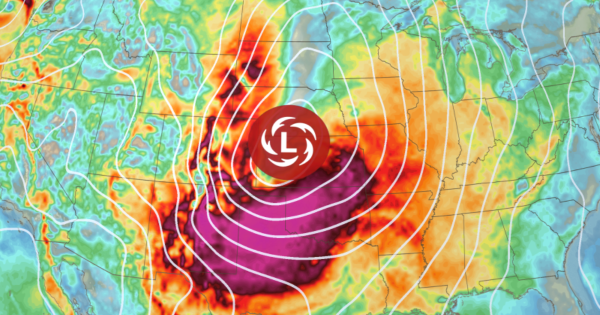
The storm will strengthen quickly and become quite intense while it tracks into the Plains, setting up a repeat of last week’s severe thunderstorm threat, widespread strong winds and increased fire danger.
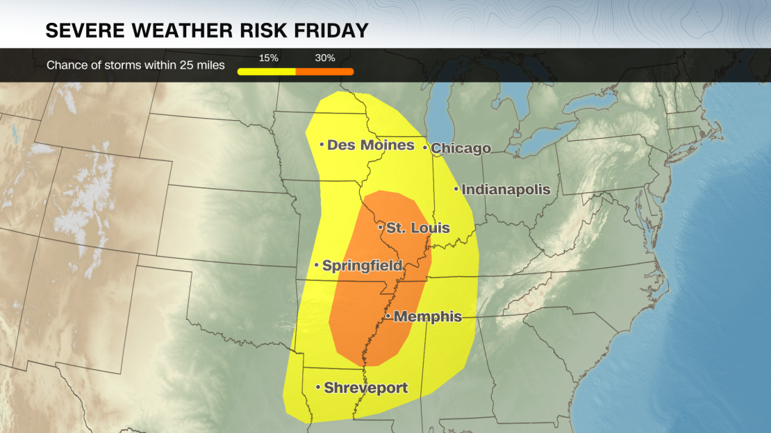
Severe thunderstorms could roar to life by the late afternoon in parts of the southern Plains and Mississippi Valley as the powerful storm’s potent cold front clashes with a surge of warm, moist air from the Gulf.
The thunderstorms will become more ferocious and expand by the late evening to pound potentially more than 800 miles of the Mississippi Valley – from Louisiana through Iowa – into the overnight hours. Damaging wind gusts, hail and tornadoes will all be possible.
Strong winds that could disrupt travel and damage power lines will also whip across the central US ahead of any thunderstorms. Winds will quickly go from quite breezy early in the morning to fierce by the end of the day.
Widespread gusts of 40 to 50 mph are likely by late afternoon, with stronger gusts up to 65 mph in parts of Texas and New Mexico.
The winds will also ramp up fire danger in eastern New Mexico and the Southern Plains to the extreme. Dozens of fires flared up in Texas last week under similar conditions.
The intense cross-country storm will expand into more of the eastern US with severe thunderstorms and blizzard conditions.
Severe thunderstorms could be ongoing in the early morning, especially in parts of the Ohio Valley.
Some of these storms could become less intense by the afternoon but the threat won’t end there – another round of dangerous storms will surge to life in the afternoon along the Gulf Coast and in the Southeast.
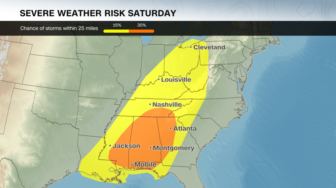
Damaging wind gusts, hail and tornadoes will all be possible, especially into the overnight hours.
These hazards take on another layer of danger when it’s dark and difficult to see: Nighttime tornadoes are nearly twice as likely to be deadly as those occurring during the day, a 2022 study found.
Snow, ice, rain and strong winds will slam the north-central US starting in the earliest hours of Saturday morning. The combination could cause periods of blizzard conditions – blowing snow that makes it difficult or impossible to see more than a few feet.
Last week’s storm created a blizzard that shut down highways, stranded vehicles and caused crashes across multiple states.
The storm’s widespread, powerful winds will ease up over the Plains through Saturday and move farther east.
Sunday will likely be a wet and stormy day for much of the East Coast. Some severe thunderstorms with strong winds could linger into Sunday, but will likely be less intense than Friday and Saturday’s storms.
CNN meteorologists Allison Chinchar and Robert Shackelford contributed to this report.