Severe thunderstorms are likely from Texas’s Permian Basin up to the Canadian border Tuesday, bringing the risk of damaging winds and large hail. Some of the storms in Texas could even produce tornadoes, while Oklahoma is in line for days of possible flooding, as heavy rains could dump up to 5 inches through Wednesday.
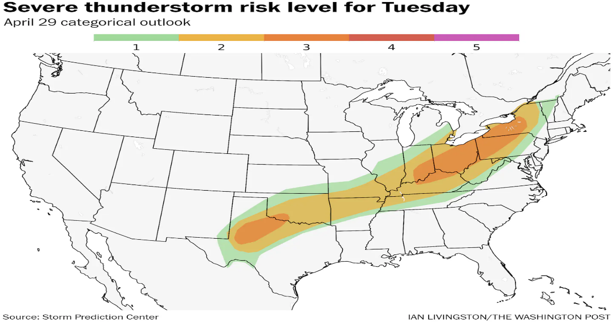
The National Weather Service Storm Prediction Center has drawn two enhanced (Level 3 out of 5) severe-weather risk zones: One stretches from Upstate New York to northwest Kentucky and southeast Illinois; the other covers parts of western Central Texas, including Midland, Wichita Falls and Lubbock, as well as Fort Sill, Oklahoma.
The southern Plains will face more severe storms Wednesday, with a chance of tornadoes around the Dallas-Fort Worth metropolitan area.
The stormy pattern over the central U.S. should simmer down by Thursday, and then a renewed severe-weather threat crops up early next week.
The day began stormy in the Ozarks, with severe-thunderstorm watches in effect for northern Arkansas and southern Missouri. A few pockets of damaging winds are likely; leftover storms from Monday night have merged into windy complexes.
Into Tuesday afternoon, there are two zones of increased severe weather potential.
Parts of the Appalachians and Midwest will see scattered severe storm complexes pushing eastward. They’re forming along a cold front that’s slowly sagging southeast into warm, humid air. That mildness and moisture represents instability, or thunderstorm fuel.
Thunderstorms that grow tall will be affected by the jet stream sweeping overhead. That will help some of the storms produce damaging gusts. (The stronger storms will effectively take jet stream momentum from above and transfer it to the surface in the form of 60 mph surface gusts).
Some hail is possible, too, perhaps up to the size of half-dollars.
There could be some isolated tornado potential in Ohio, Pennsylvania or western New York state; that includes Columbus, Cincinnati, Pittsburgh, Buffalo and Rochester.
The other enhanced area in Texas and southwest Oklahoma covers Lawton-Fort Sill in Oklahoma; and Lubbock, Childress, Paducah, Vernon and Quanah in Texas, as well as surrounding areas.
Storms there will get a nudge by the dryline, or an insurgence of dry air from the Desert Southwest encroaching on Gulf moisture to the east. These storms will be stronger, and a nearby surface low will also boost low-level easterly winds enough to help drive rotation within storms.
Destructive hail up to pool ball size, damaging winds and a couple of tornadoes are possible.
Flooding will be an increased concern across the southern half of Oklahoma and adjacent north Texas. Repeated rounds of heavy rain will be possible through late Wednesday, which could dump a general 3 to 5 inches. Localized amounts exceeding 6 inches are possible.
The National Weather Service Weather Prediction Center has outlined a moderate (Level 3 out of 4) risk of flash flooding and excessive rainfall around much of Oklahoma on Tuesday. The risk area shifts east Wednesday.
There are two main elements driving the potential flooding. For starters, the instigating front is collapsing southeast very slowly. Moisture pooling along the front will continue to spur downpours until the front finally clears south and east.
Second, mid-level winds are parallel to the front. That means storms that form on the front area steered northeast along the front — akin to railcars on a train track. Storms will continue to ride the front, passing over the same areas time and time again. That will lead to a narrow but impactful rainfall jackpot.