TOWN. IT IS COMING UP ON 618. THERE’S A LOT OF UNCERTAINTY WITH THE FORECAST, WHICH IS WHY THE APP IS GOING TO BE SO CRITICAL TODAY BECAUSE THESE STORMS SOUND LIKE THEY COULD POP UP IN JUST A MINUTE. YEAH, THEY REALLY COULD. WE MAY SEE JUST 1 OR 2 STORMS HERE ACROSS CENTRAL IOWA. AND THAT MAKES IT REALLY HARD TO SAY EXACTLY WHERE THEY’RE GOING TO BE. BUT IF YOU GET IMPACTED BY 1 OR 2 OF THOSE STORMS, YEAH, THEY COULD REALLY PACK A PUNCH WITH SOME SIGNIFICANT WEATHER HERE BY THIS EVENING. THE REST OF THE DAY IS JUST GOING TO BE WARM, WINDY AND HUMID. YEAH, YOU’RE GOING TO NOTICE THE HUMIDITY TODAY. TEMPERATURES IN THE 60S THIS MORNING WILL WARM INTO THE 70S BY THE LUNCH HOUR. HIGHS TODAY IN THE 80S 82 DEGREES. OUR AVERAGE HIGH FOR THIS TIME OF YEAR 66. SO WE’RE WELL ABOVE THAT. BUT UNFORTUNATELY THAT’S ALL FUEL FOR THOSE STORMS THAT TRY TO FIRE UP THIS AFTERNOON. AND ANY THUNDERSTORM THAT FORMS WILL BE CAPABLE OF SEVERE WEATHER. THE QUESTION MARK IS HOW WIDESPREAD WILL THOSE STORMS BE? RIGHT NOW, IT APPEARS THE MOST LIKELY AREA TO SEE SEVERE WEATHER IS GOING TO BE ACROSS NORTHERN IOWA, MOSTLY NEAR AND NORTH OF HIGHWAY 20. SO FORT DODGE, IOWA FALLS, ALGONA, MASON CITY, OVER TOWARD WATERLOO. THAT’S WHERE WE COULD SEE THOSE STORMS THIS EVENING. THE REST OF THE STATE. YES, WE HAVE A SEVERE WEATHER RISK, BUT CHANCES ARE WE ONLY SEE 1 OR 2 STORMS, SO IT’S REALLY HARD TO SAY WHERE IN THIS ZONE THAT THOSE STORMS WILL FORM. BUT AGAIN, ANY STORM THAT FORMS HAIL, HIGH WINDS AND EVEN A TORNADO. NOT OUT OF THE QUESTION. SO HERE’S HOW IT PLAYS OUT THROUGH THE REST OF THE DAY. CLOUDY SKIES THIS MORNING. THERE COULD BE A SHOWER OR STORM HERE NORTH OF HIGHWAY 20. OVER THE NEXT COUPLE OF HOURS SEEMS UNLIKELY, BUT JUST BE READY FOR A QUICK DOWNPOUR. IT’S NOT GOING TO BE SEVERE. THEN THROUGH THE LUNCH HOUR THE CLOUDS START TO THIN OUT. WE SEE MORE SUNSHINE. TEMPERATURES CLIMB, THE HUMIDITY CLIMBS AS WELL. ALL OF THAT IN ADVANCE OF THE POTENTIAL FOR THE SEVERE STORMS. SO BY 1 TO 2:00 WE’RE GOING TO BE WATCHING NORTHWEST IOWA WEST OF STORM LAKE. SPENCER. WEST OF ALGONA FOR THOSE STORMS TO FIRE OFF. WATCH WHAT HAPPENS BETWEEN ABOUT TWO AND 3:00. BOOM. THOSE STORMS GO OFF. THEY WILL DEVELOP QUICKLY. AND WHEN THEY FORM, THEY WILL QUICKLY GO FROM JUST A REGULAR THUNDERSTORM TO A SEVERE STORM WITH HAIL AND HIGH WINDS AND EVEN A RISK FOR TORNADOES. THESE STORMS CONTINUE TO TRACK ACROSS NORTHERN IOWA. SO ALGONA, MASON CITY, MAYBE EVEN FORT DODGE AGAIN, IOWA FALLS, YOU HAVE TO WATCH THOSE STORMS THERE. NORTH OF HIGHWAY 20. AND THEN AS WE WORK INTO THE LATER EVENING HOURS, WE WILL WATCH THE POTENTIAL FOR 1 OR 2 STORMS TO DEVELOP SOMEWHERE HERE ACROSS CENTRAL IOWA, IT’S NOT CLEAR EXACTLY WHERE THAT STORM WOULD BE, BUT WHERE THAT STORM DEVELOPS. IT’S DEFINITELY GOING TO PACK A PUNCH, AND THEN IT WILL PUSH OFF TO THE EAST AND STORMS START TO DIE DOWN. ONCE WE GET PAST ABOUT 8 TO 9:00 THIS EVENING. SO AGAIN, ANY STORM THAT FORMS HIGH WINDS, MAYBE UP TO 75 MILES AN HOUR, LARGE HAIL, PERHAPS AS LARGE AS BASEBALLS WITH THE STRONGEST STORMS. AND THERE’S A RISK FOR TORNADOES. BUT CONDITIONS ARE NOT FAVORABLE FOR TORNADO OUTBREAK. BUT YOU CAN NEVER RULE OUT A TORNADO WITH A SEVERE THUNDERSTORM. SO REALLY GOT TO PAY ATTENTION WHEN THOSE STORMS START TO FIRE OFF. THANKFULLY, AT THE MOMENT WE’RE PRETTY QUIET WATCHING THE SHOWER AND THUNDERSTORM ACTIVITY HERE ACROSS SOUTH DAKOTA, MOVING INTO MINNESOTA. SOME OF THESE MAY KICK OFF A SHOWER OR STORM THERE IN NORTHERN IOWA OVER THE NEXT HOUR OR TWO, BUT THAT SHOULD MOVE OUT BY MID-MORNING. THAT STORM SYSTEM OFF TO THE WEST. THAT’S WHAT’S RESPONSIBLE FOR OUR SEVERE WEATHER RISK 61 DEGREES RIGHT NOW. IT’S A MILD MORNING, MID 60S, OFF TO THE WEST OF THE METRO. THANKS TO THIS SOUTH WIND RIGHT NOW COMING IN AT 20 MILES AN HOUR. SOME GUSTS UP TO ABOUT 40 MILES AN HOUR HERE LATER TODAY. SO IF YOU HAVE OUTDOOR PLANS AHEAD OF THOSE STORMS, IT’S GOING TO BE WINDY OUT THERE. CERTAINLY WARM AND HUMID AS WELL. STORMS MOVE OUT OVERNIGHT TOMORROW THE SUNSHINE IS BACK. A LITTLE BREEZY AND COOLER, BUT NOT A BAD DAY. A HIGH OF 65. MORE RAIN IS IN THE FORECAST ON WEDNESDAY, BUT RIGHT NOW THAT LOOK
Iowa weather: Warm and humid, severe storms possible this afternoon
Gusty south winds will pump in very warm and humid air today setting the stage for potential severe storms this afternoon and evening.
 Updated: 8:21 AM CDT Apr 28, 2025
Warm and humid air is already pushing in across the state this morning thanks to a steady overnight south breeze. Temperatures are starting out near 60 degrees, and highs today should climb into the 80s with increasing humidity. Scattered severe storms are possible by this afternoon, especially across northwest and northern Iowa.Interactive Radar | Weather AlertsA strong spring storm system will bring very active weather to the Midwest today. South winds gusting up to 40mph will help temperatures to quickly climb today, from the low 60s this morning into the mid-70s by Noon. Afternoon highs should top out in the low to mid-80s for much of the state, well above average for this time of year. Humidity levels will also be increasing, in fact it may be the first really humid day of the year, feeling a bit more like summer this afternoon.The warm, humid, and windy conditions in place will set the stage for at least a few severe storms by this afternoon and evening. Storm chances will increase initially over northwest Iowa, as a wind shift starts to push into the state and kicks off some scattered storms. However, that front may not have enough energy to sustain the storms, or fill in the line of storms across the rest of western Iowa. Where storms develop, significant severe weather is possible with large hail, damaging winds, and even a few tornadoes. However, it does not appear that conditions are in place for a tornado outbreak in Iowa.The line of storms should continue to press east into north-central Iowa by early evening continuing the risk for significant severe weather, especially north of Highway 20. It it not clear just yet if storms will be able to fill in south of Highway 20 for central Iowa. If those storms are able to develop, severe weather is likely. However, it is entirely possible that no storms develop over central Iowa with this first round of severe storms.Later tonight, a cold front will push across the state and could spark additional storms. This would be most likely between 8pm and Midnight. These storms could be severe, but the risks with any of these storms would be lower than with any storms that develop this afternoon.Any lingering storms will move out overnight with sunny, though slightly breezy conditions returning for Tuesday. Highs will fall back into the mid-60s for Tuesday afternoon. Our next rain chances arrives on Wednesday, with widespread rain showers possible, especially over southern Iowa. This will keep temperatures a little cooler, with highs in the upper 50s to low 60s. More sunshine and highs in the 70s are back in the forecast by the end of the weekend.Des Moines ForecastToday: Clouds early, becoming partly sunny, windy, and humid. Scattered thunderstorms possible in the late afternoon. Storms could be severe. High 82F. Winds S at 25 to 35 mph.Tonight: Scattered thunderstorms early in the evening, then clear. Storms could be severe. Gusty winds diminishing after midnight. Low 47F. Winds WSW at 20 to 30 mph.Tomorrow: Sun and a few passing clouds. High 65F. Winds NNW at 15 to 25 mph.Tomorrow Night: Partly cloudy. Low 46F. Winds E at 5 to 10 mph.
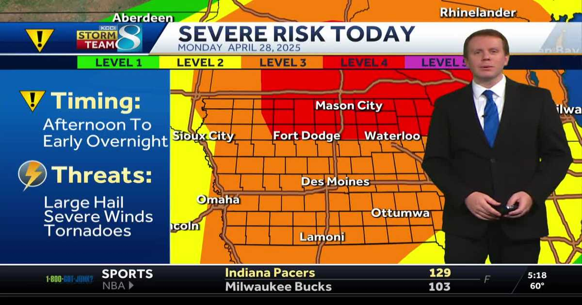
DES MOINES, Iowa —Warm and humid air is already pushing in across the state this morning thanks to a steady overnight south breeze. Temperatures are starting out near 60 degrees, and highs today should climb into the 80s with increasing humidity. Scattered severe storms are possible by this afternoon, especially across northwest and northern Iowa.
Interactive Radar | Weather Alerts
A strong spring storm system will bring very active weather to the Midwest today. South winds gusting up to 40mph will help temperatures to quickly climb today, from the low 60s this morning into the mid-70s by Noon. Afternoon highs should top out in the low to mid-80s for much of the state, well above average for this time of year. Humidity levels will also be increasing, in fact it may be the first really humid day of the year, feeling a bit more like summer this afternoon.

The warm, humid, and windy conditions in place will set the stage for at least a few severe storms by this afternoon and evening. Storm chances will increase initially over northwest Iowa, as a wind shift starts to push into the state and kicks off some scattered storms. However, that front may not have enough energy to sustain the storms, or fill in the line of storms across the rest of western Iowa. Where storms develop, significant severe weather is possible with large hail, damaging winds, and even a few tornadoes. However, it does not appear that conditions are in place for a tornado outbreak in Iowa.

The line of storms should continue to press east into north-central Iowa by early evening continuing the risk for significant severe weather, especially north of Highway 20. It it not clear just yet if storms will be able to fill in south of Highway 20 for central Iowa. If those storms are able to develop, severe weather is likely. However, it is entirely possible that no storms develop over central Iowa with this first round of severe storms.
Later tonight, a cold front will push across the state and could spark additional storms. This would be most likely between 8pm and Midnight. These storms could be severe, but the risks with any of these storms would be lower than with any storms that develop this afternoon.
Any lingering storms will move out overnight with sunny, though slightly breezy conditions returning for Tuesday. Highs will fall back into the mid-60s for Tuesday afternoon. Our next rain chances arrives on Wednesday, with widespread rain showers possible, especially over southern Iowa. This will keep temperatures a little cooler, with highs in the upper 50s to low 60s. More sunshine and highs in the 70s are back in the forecast by the end of the weekend.
Des Moines Forecast
Today: Clouds early, becoming partly sunny, windy, and humid. Scattered thunderstorms possible in the late afternoon. Storms could be severe. High 82F. Winds S at 25 to 35 mph.
Tonight: Scattered thunderstorms early in the evening, then clear. Storms could be severe. Gusty winds diminishing after midnight. Low 47F. Winds WSW at 20 to 30 mph.
Tomorrow: Sun and a few passing clouds. High 65F. Winds NNW at 15 to 25 mph.
Tomorrow Night: Partly cloudy. Low 46F. Winds E at 5 to 10 mph.