EAST TEXAS (KLTV/KTRE) – A First Alert Weather Day remains in effect for Easter Sunday. An upper-level storm system moving into the Central U.S. is beginning to slow down and lose some of its energy. This will lessen rain chances for the holiday weekend.
A few isolated showers and storms will possible Saturday evening and overnight, but most of East Texas will remain dry. Easter Sunday will start off with scattered showers ahead of the cold front that looks to move into East Texas by late Sunday morning. Thunderstorm development will be likely along the front, mainly south of I-20, through the afternoon and evening hours. Showers and storms could last late Sunday night into Monday morning before the front finally pushes through by Monday afternoon.

Easter Sunday Severe Weather Risk(KLTV)
Widespread severe weather is NOT expected in East Texas, but any storms that develop do have the ingredients to become strong to severe. The main threats would be gusty, damaging winds and small hail. Please remain weather alert and start making some indoor back-up plans to be safe. Stay tuned to KLTV and KTRE for updates on-air, online, and on all of our digital platforms.
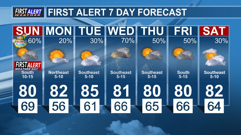
First Alert 7 Day Forecast(KLTV)
Copyright 2025 KLTV/KTRE. All rights reserved.