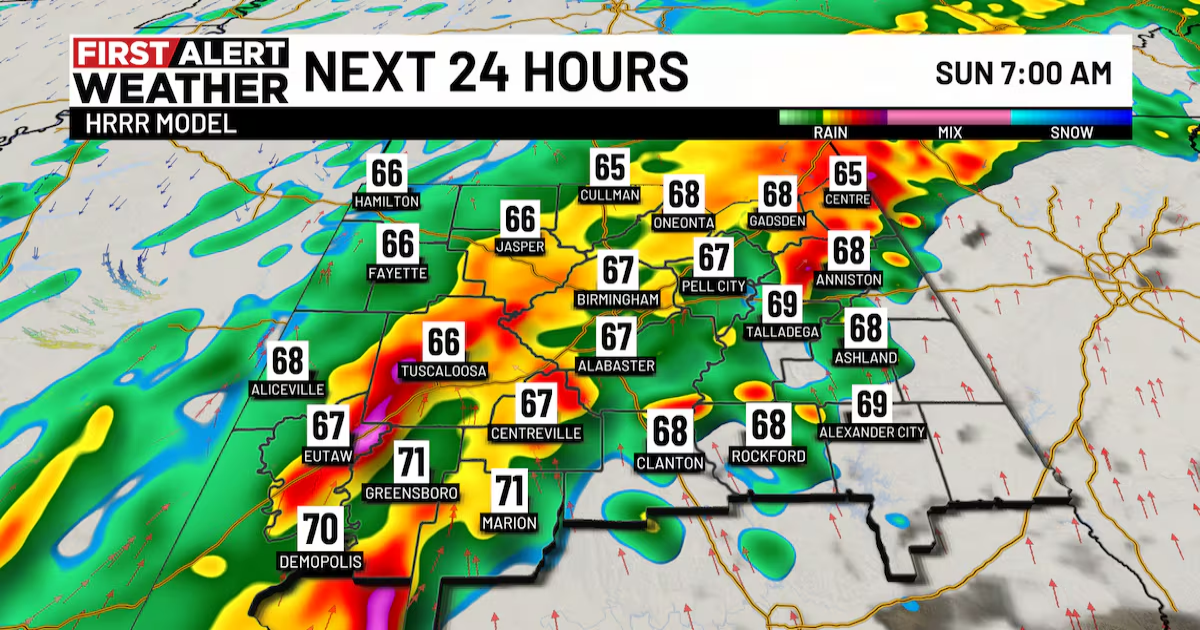
BIRMINGHAM, Ala. (WBRC) – A First Alert Weather Day is in place for Sunday with a flooding and severe risk possible as a line of storms moves in after midnight. These storms will push to the southeast and impact all of Central Alabama Sunday morning with rain lingering through the afternoon and evening hours. We think the greatest window for strong and severe storms will likely occur between 12 a.m. CDT – 2 p.m. CDT Sunday. The main threats will be damaging wind gusts and large hail.
The tornado threat remains low in this setup but not zero. The greatest risk will be to the northwest overnight but shift to the south and east by the late morning and afternoon hours on Sunday. For now, a Tornado Watch is in effect for Marion, Winston, and Cullman Counties until 3 a.m. CDT Sunday. Not everyone is guaranteed to see severe weather; most of us will end up with rounds of steady to heavy rainfall and gusty winds up to 30-40 mph. A Flood Watch is in effect from 9 p.m. CDT tonight through 7 a.m. CDT Monday. A widespread 2-3 inches of rain could fall across our area with isolated higher amounts of 4-5 inches possible.
Sunday morning will be on the wet side, but rain chances may start to decrease in Northwest Alabama late Sunday afternoon. The bulk of the rain will remain along and south of I-20/59 Sunday evening. Temperatures Sunday morning will likely start out in the low to mid 70s. Temperatures will cool into the 60s Sunday afternoon thanks to clouds and rainy conditions. Winds tomorrow will come from the southwest at 10-15 mph with gusts up to 25 mph. Winds will begin to shift from the southwest to the northwest Sunday night as cooler air begins to push into Central Alabama.
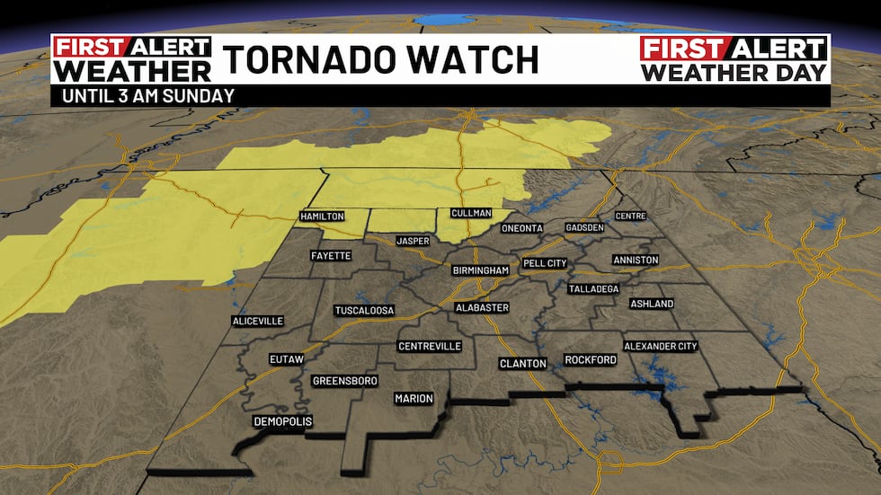
Tornado Watch(WBRC)
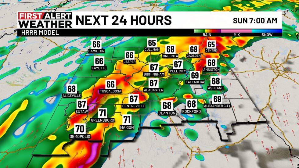
Next 24 Hours(WBRC)
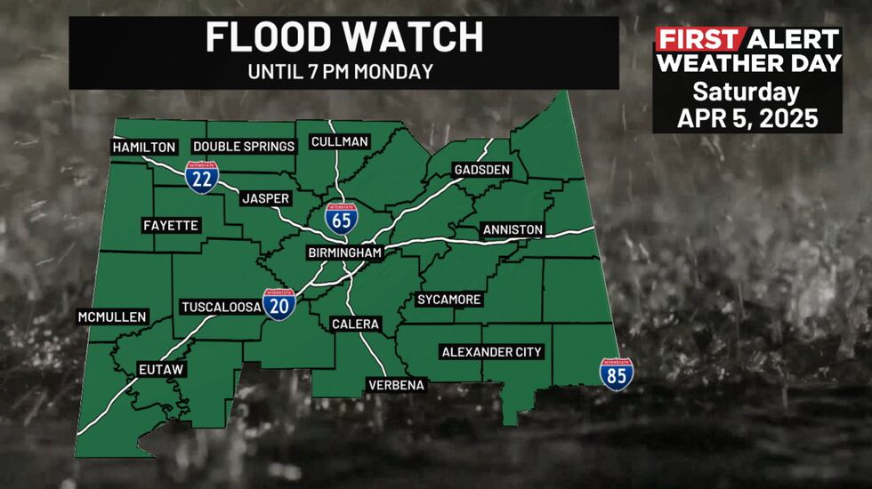
Flood Watch(WBRC)
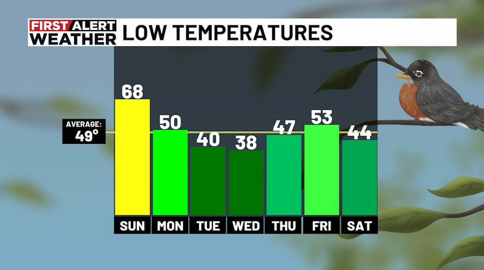
Chilly temperatures Monday: We have a First Alert for you to grab the jacket as we start the new week! Cool and drier air will move into Central Alabama for the first half of the week. We’ll start Monday morning with a mostly cloudy sky with temperatures in the upper 40s and lower 50s. We will hold on to a small chance for a few showers mainly south of I-20/59 Monday morning. Monday afternoon will likely trend dry with highs only climbing into the upper 50s with a mostly cloudy sky. With breezy conditions, it’ll definitely feel a little chilly if you plan to be outdoors.
Frost possible next week: Models continue to show morning temperatures dropping below average Tuesday and Wednesday morning. We could see temperatures drop into the lower 40s Tuesday morning. Tuesday will end up sunny and cool with highs in the mid 60s. The coldest morning this week may occur on Wednesday. A few models are hinting at temperatures cooling into the mid to upper 30s. If this happens, we may see some patchy frost for areas along and north of I-20. You may consider covering or bringing any sensitive plants indoors. The good news next week is the weather pattern will end up dry and nice. We’ll likely see plenty of sunshine next week with highs in the 70s next Wednesday through the following weekend. A small chance of rain will be possible next Thursday night into Friday morning.
Low Temperatures(WBRC)
Make sure you download the WBRC First Alert Weather App for the latest weather information.
Have a wonderful weekend!
Get news alerts in the Apple App Store and Google Play Store or subscribe to our email newsletter here.
Copyright 2025 WBRC. All rights reserved.