SAGINAW, Mich. (WNEM) – It’s been the big story for the last several days and now we’re watching the potential for strong to severe thunderstorms around Mid-Michigan tonight.
Tornado Watches and Severe Thunderstorm/Tornado Warnings have been issued in parts of Wisconsin and Minnesota this afternoon and now we watch the progress through the evening and early overnight hours. We still have several hours before there is any threat here, but if you are going to bed tonight before storms arrive, have a way to receive warnings if you’re sleeping, just in case.
If any watches or warnings are issued in our area, you can find them on our Weather Alerts page and we’ll have updates on-air if needed, and online/social media through the night. For a complete forecast look, be sure to check out your TV5 First Alert 7-Day Forecast!
This Evening & Overnight

Tonight’s severe weather outlook.(WNEM)
We expect dry weather for the next several hours for most of the area, with only an isolated chance of a shower or storm this evening. Any evening plans prior to sunset should largely be in good shape, with another beautiful evening around Mid-Michigan.

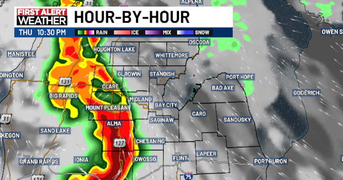
What the radar may look like at 10:30 PM tonight.(WNEM)
We think storms will be approaching the Lake Michigan shoreline around 8-9 PM, which is when you should start monitoring conditions, with an arrival time near US-127 and our western zones around 10-11 PM. These storms will likely move into the Tri-Cities and Saginaw Bay regions around midnight (give or take), and will move into the Thumb between 12:30 AM and 2 AM based on current projections.

What the radar may look like at 11:30 PM Thursday.(WNEM)
The question of the last few days and the question that remains tonight is how well these storms hold their intensity as they move into our local area. We are already seeing severe weather to our west tonight in Wisconsin and Minnesota, and we expect storms to become severe in West Michigan as well. As they start to approach our area tonight, instability (storm energy) will be gradually dropping off as we lose the heat of the day, which could diminish the intensity. Storms may also be cut off from the best ingredients near ground level if our “cap” holds.

What the radar may look like at 12:30 AM Friday.(WNEM)
This concern with storm intensity is highlighted by the drop off in the Storm Prediction Center’s outlook that has the Enhanced Risk (numerous severe storms expected) primarily to our west, and we’re under a Slight Risk. That is still a noteworthy risk level, but it illustrates the trend that storms could drop off a bit as they move east. Does that mean they drop off from a higher than typical intensity to our west (hail 2″+ in size, 70+ mph winds, better tornado chance) and remain severe here with a more typical 60 mph wind and 1″ hail? Or do they fall below severe limits entirely? It’s important to know, we expect storms regardless. It is the intensity that is in question for us.
If storms become severe, we expect large hail and damaging wind gusts to be the main threat for us. The tornado risk is not as high as the west side of the state, but an isolated tornado can’t be ruled out. Flooding is not expected as the window for rain in any one spot is expected to be around 1 hour or less with how quickly these storms are expected to pass through.
Remember, severe storm is no guarantee for any one location. There will be many who just receive rain tonight and others who receive just general thunderstorms. But this is a night where things are better played safe than sorry.
With the late night arrival, be sure to have a way to receive watches and warnings if you go to bed before storms arrive. It also wouldn’t be a bad idea to park the car in the garage if you can tonight and secure any objects that could blow around easily, just in case.
Lows tonight will drop into the 50s and 60s.

Low temperatures tonight.(WNEM)
Friday

Our severe weather outlook for Friday.(WNEM)
We expect much of Friday to be dry with plenty of sun and warm temperatures once again. But we will be watching another chance for showers and thunderstorms on Friday evening, mainly after sunset once again. These storms will have a chance to produce some stronger wind gusts and hail once again, and there is a possibility that even just showers could be gusty as they come through.

What the radar may look like at midnight Friday night.(WNEM)
Gusts on Friday will also be around 25 to 30 miles per hour, with sustained southwest winds around 10 to 20 miles per hour. High temperatures on Friday will be in the 80s for most of Mid-Michigan, with cooler temps to the east, however the southwesterly flow offshore should allow some of these areas to be warmer than most of the other days we’ve had.

High temperatures for Friday.(WNEM)
Showers could linger into Friday night and Saturday, but shouldn’t be severe the further into Friday night we go. More specifics will be available tomorrow.
Copyright 2025 WNEM. All rights reserved.