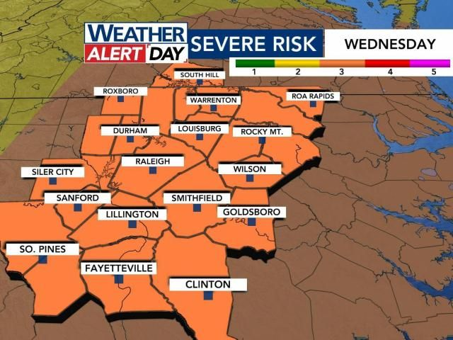
Much of central North Carolina, including our area, is under a Level 3 (out of 5) risk for severe storms Wednesday. A Level 3 risk is uncommon for our area and indicates storms may be more numerous, persistent and widespread.

Risk level and potential threats for 3/5/2025
“For our area it doesn’t happen very often, but it does mean that we have to take this very seriously,” WRAL meteorologist Aimee Wilmoth said.
Storms won’t roll in until after 8 a.m. on Wednesday, but winds could start to pick up in the morning.
That’s why a Wind Advisory is in effect for much of North Carolina Wednesday.

A wind advisory is in effect Wednesday between 4 a.m. and 7 p.m., and scattered power outages will be possible.
What is our risk level for severe thunderstorms Wednesday?
NOAA’s Storm Prediction Center has placed our areas under a Level 3 risk out of 5 for severe thunderstorms Wednesday.

Level 3 risk across the area on 3/5/2025
The National Weather Service in Raleigh says the last time we had a Level 3 risk on the Day 2 outlook was Aug. 7, 2023. WRAL reported 80,000 without power in the Triangle from that day.

Level 3 risk explained for Wednesday’s WRAL Weather Alert Day 3/5/2025
Granted, we hit 90 degrees that day, and there was a lot more lightning with that line of storms. It’s unlikely we see 80,000 without power this time around, but we discuss power outages below.
Tune in to WRAL News+ for the latest info on timing & impacts of Wednesday’s storms
What does a “Level 3” risk of severe weather mean?
This has increased since Monday. A Level 3 indicates that ‘numerous’ reports of severe weather damage will happen.

What a Level 3 risk of severe storms means
Wind damage from straight-line gusts is of growing concern as of this latest outlook.
When is this expected to happen?
This will be a line/a broken line of showers and storms that moves from west to east between about 9 a.m. and 2 p.m.
Areas west of Raleigh can expect the worst of the weather to start by 10 a.m. This will move east through 2 p.m., and it will be out of our area for the evening commute.

Storm start time for 3/5/2025
A few isolated storms will be possible during the evening, but the “main event” will be late morning/early afternoon.
We’ll stay windy at times into Thursday, as our area of low pressure swirls to the north.
Can you show us FutureCast?
FutureCast relies on short-term, high-resolution data. We’ve got a first look at that Monday morning, and it updates every six hours.
I’ve split it up into four panels below to give you an estimate of the timing.

FutureCast 4 Panel for 3/5/2025
What are the main threats?
In a case like this, damaging wind gusts are the main thing we’ll track. The most extreme gusts could reach/exceed 70 mph, which is why our threat level is higher-than-usual. Sometimes, these lines of storms can have rotation on their northern edges, so the tornado threat is not zero. (It is not comparable to April 16, 2011. We’ve had some questions about that.)

Severe threat levels for 3/5/2025
We are not expecting widespread, large hail or flooding at this time.
Are power outages a concern?
Given the potential for damaging wind gusts, I would say that power outages are of potential concern. We saw that happen a few Sundays ago when a similar line pushed through central North Carolina and knocked out power to thousands.

Power outage potential for Wednesday, 3/5/2025
NOAA’s Storm Prediction Center indicates that scattered gusts of 70-75 mph will be possible throughout the Carolinas.
What is the difference between a watch and a warning?
A watch means that something is possible/conditions are favorable within the next few hours. This is when you prepare.
A warning means that something is imminent or currently happening. This is when you take action.
Is there any way this changes, and we don’t get severe storms?
A lot of times, we’ll use the acronym SLIM to diagnose severe weather possibilities.
This acronym stands for:
- Shear: The changing of winds with both speed and height. This helps maintain storms as the move west to east.
- Lift: Rising air in the atmosphere allows storms to develop and precipitation to get going.
- Instability: Storm fuel for thunderstorms to reach their fullest potential.
- Moisture: This needs no explanation.
There is plenty of wind shear in the atmosphere to allow for strong wind gusts. The instability is questionable, which could be a limiting factor in our severe potential.
You’re rooting for an earlier start time. That would prevent the atmosphere from warming and becoming unstable.
I have a flight. Do you expect delays?
This is always a challenging question to answer. If you plan on flying to Houston, Chicago, St. Louis, Kansas City, Memphis, etc. on Tuesday, you may very well have some delays. In terms of our weather, I could see there being at least brief delays at RDU as the line passes through, but I cannot speak to cancellations.
Do you expect changes to school schedules?
This is again one of those questions that I cannot entirely answer, since we’re not involved in those decisions. I will say that the worst of the weather looks like it would come in after bus stop time.
I have seen school systems amend schedules or after-school programs in the past when there’s the potential for severe thunderstorms.
How do we get warnings?
If a tornado warning is issued, we will be live in continuous coverage on all platforms.