STORMS SO YOU’LL KNOW. FIRST, THIS IS WVTM 13 WEATHER. A CONFIRMED TORNADO WARNING IS IN PLACE FOR PARTS OF COLBERT, LAUDERDALE AND THE NORTHWESTERN EXTENSION OF FRANKLIN COUNTY. YOU CAN SEE THIS BAND OF RAIN MOVING THROUGH CHEROKEE AND PARTS OF CEDAR HILLS ESTATE SOON, BUT I WANT TO GET DOWN AND LOOK AT THE STORM. RELATIVE VELOCITY HERE, AND YOU CAN SEE THE ROTATION THAT COULD POTENTIALLY BE A TORNADO ON THE GROUND. TYPICALLY WHEN THEY SHADED THAT PINK COLOR, IT’S PRETTY MUCH CONFIRMED. SO IF YOU KNOW ANYONE NEAR CHEROKEE ALONG HIGHWAY 72, ALONG HIGHWAY TWO, 47, TELL, GIVE THEM A CALL AND TELL THEM TO GO TO THEIR SAFE PLACE. NOW, THERE IS LIKELY A CONFIRMED TORNADO ON THE GROUND. MEANWHILE, THERE’S ANOTHER TORNADO WARNING BACK BEHIND THAT IN MISSISSIPPI. NOT CONFIRMED, BUT STILL POSSIBLE. BUT THE MAIN THREAT WITH THIS ENTIRE LINE OF THUNDERSTORMS THAT PARTS OF TENNESSEE AND ARKANSAS HAVE BEEN SEEING FOR THE PAST FEW DAYS IS THE FLOOD THREAT. FLASH FLOOD WARNINGS STRETCH ACROSS MUCH OF THE SOUTHEAST, AND THAT’S ALSO GOING TO BE THE MAIN THREAT, AS THIS LINE OF THUNDERSTORMS PUSH OUR WAY. NOW, THE STORM PREDICTION CENTER HAS OUTLINED A VERY SMALL LEVEL FOUR OF FOUR RISK FOR EXTREME NORTHWEST ALABAMA AND NORTHEAST MISSISSIPPI. AS YOU CAN SEE, THAT’S WHERE THAT WARNING WAS. BUT AS THIS SYSTEM CONTINUES TO PUSH EASTWARD, THE RISK DROP OFF PRETTY QUICKLY. ENHANCED RISK DOWN THROUGH MARIANNA LAMAR COUY IS A LEVEL TWO THREAT AS WE MOVE INTO CULLMAN. WALKER, TUSCALOOSA COUNTY, TUSCALOOSA COUNTY, AND THAT’S THROUGH 7 A.M. SUNDAY MORNING. AND THEN AFTER THAT, THIS IS THE EXTENDED OUTLOOK, A LEVEL TWO RISK FOR THE REST OF ALABAMA. SO WHILE THE POTENTIAL FOR TORNADOES ARE MUCH HIGHER UP THERE IN THAT NORTHWESTERN CORNER, THE REST OF ALABAMA, THAT RISK IS A LOT LESS. AND THAT’S WHY A TORNADO WATCH IS IN PLACE FOR COLEMAN, WINSTON MARION COUNTY, LAWRENCE, LAUDERDALE, PARTS OF MADISON, MORGAN COUNTIES BECAUSE THAT’S WHERE THE INGREDIENTS LOOK THE BEST FOR A POTENTIAL TORNADO. SO IF YOU’RE IN THOSE COUNTIES THAT I JUST MENTIONED, AT LEAST UNTIL 3 A.M., YOU KIND OF WANT TO STAY UP AND AWAKE. AT THE VERY LEAST, HAVE A VERY LOUD WAY TO RECEIVE WATCHES AND OR WARNINGS IF YOU DO FALL ASLEEP. NOW, HERE ARE THE MAIN IMPACTS AGAIN FOR ALABAMA. I ALREADY MENTIONED THAT FLOOD THREAT, BUT WE COULD SEE SOME DAMAGING WIND GUSTS WITHIN SOME OF THESE ISOLATED THUNDERSTORMS. AND THEN STILL A LOW END TORNADO THREAT, BUT IS NOT THE MAIN THREAT. WE’RE NOT EXPECTING WIDESPREAD SIGNIFICANT TORNADOES OR CATASTROPHIC AREAS OF TORNADOES EITHER, SIMILAR TO WHAT WE SAW A COUPLE OF WEEKENDS AGO. I WANT TO KIND OF STRESS HERE THAT THE MAIN THREAT IS THE FLASH FLOODING POTENTIAL. NOW, HERE’S A FUTURECAST KIND OF SHOWING WHERE WE ARE NOW. AND BY THE TIME WE GET INTO 1 A.M. SUNDAY MORNING, IN A FEW HOURS FROM NOW, WE COULD SEE A FEW ISOLATED CELLS OUT AHEAD OF THE MAIN LINE. BUT THIS LINE HAS BEEN MOVING PRETTY SLOWLY, AND THAT’S WHY THE FLOOD THREAT IS MUCH HIGHER. THIS IS 5 A.M. AT THIS POINT. IT’S MOVING THROUGH PARTS OF BLOUNT COUNTY, CULLMAN THROUGH FAYETTE COUNTY, WALKER COUNTY, DOWN INTO TUSCALOOSA, GREENE, HALE AND SUMTER COUNTIES. SO AGAIN, YOU’LL WANT TO ALLOW WAY TO RECEIVE WATCHES AND WARNINGS. AND WHAT YOU’LL NOTICE IS SOME OF THESE LOT SOME OF THE STORMS WITHIN THE MAIN LINE KIND OF BOWS OUT AHEAD OF IT. AND THAT’S JUST KIND OF HIGHLIGHTING THE POTENTIAL FOR STRONGER WIND GUSTS WITH THIS SYSTEM. THIS IS 7 A.M. SUNDAY AT THIS POINT. THIS IS WHERE WE HAVE THE HIGHEST COVERAGE ACROSS CENTRAL ALABAMA. AND THEN BY TIME WE GET INTO 5 P.M. SUNDAY, MOST OF THIS IS TO THE EAST. AT THIS POINT, I THINK THE SEVERE WEATHER THREAT IS OVER, BUT WE STILL GOT A LOT OF RAIN TO GET THROUGH AS THIS SYSTEM, THIS LINE HERE STALLS RIGHT OVER SOUTHEAST ALABAMA. WATCH. THIS IS MIDNIGHT. AND THEN WE’RE LOOKING AT NOW 5 A.M. MONDAY MORNING HASN’T MOVED MUCH. AND THIS IS 2 P.M. MONDAY AFTERNOON. STILL PLENTY OF SHOWERS OVER EAST ALABAMA. SO THAT’S WHERE THAT HIGHEST FLOOD THREAT COULD END UP. HERE’S THE RAINFALL TOTALS OVER THE NEXT 24 TO 48 HOURS. AND YOU CAN SEE THIS IS THROUGH 8 P.M. SUNDAY. AND THE HIGHEST RAINFALL TOTALS ARE FURTHER SOUTH. BUT EVERYWHERE ELSE IN ALABAMA COULD SEE ANYWHERE BETWEEN A HALF AN INCH, ALL THE WAY UP TO 5 TO 6IN, DEPENDING ON WHERE THOSE HEAVIEST STORMS LINE UP. AND KIND OF JUST TRAIN OVER THE SAME AREA. BUT A FLOOD WATCH IS IN PLACE FROM 9 P.M. SUNDAY INTO 6 P.M. MONDAY FOR THAT REASON. HERE’S ANOTHER LOOK AT THE TIMING. 11 P.M. TO 8 A.M. FOR NORTHWEST ALABAMA, 6 A.M. TO NOON FOR THAT I-59 CORRIDOR DOWN TO GREENSBORO AND DEMOPOLIS, AND THEN 8 A.M. TO 10 P.M. FOR SOUTHEAST ALABAMA. WHAT YOU SHOULD DO NOW IF YOU’RE STILL UP, GO AHEAD AND WALK OUTSIDE. CLEAN DEBRIS FROM THOSE STREET DRAINS AND CHARGE YOUR DEVICES TO. THAT WILL KEEP THE FLOOD THREAT LOW. AND IF YOU YOUR POWER GOES OUT, YOU HAVE A WAY TO RECEIVE THOSE WATCHES AND WARNINGS. STAY INFORMED ON THE FREE WVTM 13 APP. AND BY THE TIME WE GET INTO TUESDAY, THING
Alabama weather forecast: wind, flash flooding, isolated tornado risk overnight Saturday into Sunday
 Updated: 10:58 PM CDT Apr 5, 2025
WVTM 13 LIVE DOPPLER RADAR | UPLOAD YOUR WEATHER PHOTOS | TURN ON WEATHER NOTIFICATIONSIsolated showers and downpours will develop through the evening, and they should remain weak. Stronger storms arrive late tonight, with a scattered risk for severe weather through Sunday afternoon. The potential for flash flooding remains the highest threat. Check the video for the latest forecast. SPOTTY RAIN FOR NOW Spotty showers and the occasional thunderstorm will develop in isolated spots across Central Alabama. Most people will not see rain this evening, but more widespread rain and storms return late tonight and mainly through Sunday afternoon.IMPACT DAY: SUNDAY We tagged Sunday as an “Impact Day” because, for most of the state, a line of storms will bring soaking rain and gusty winds. A few individual severe storms could pose a threat of strong wind gusts over 58 miles per hour, flash flooding, hail and a limited threat of tornadoes.CURRENT WATCHES & WARNINGS The National Weather Service (NWS) placed a flood watch for North and Central Alabama through Monday evening. NWS also issued a tornado watch for Colbert, Lauderdale, Winston, Marion, Cullman, Madison, Morgan, Limestone and Franklin counties until 3 a.m. A new tornado watch could be extended into Central Alabama later tonight.NEWEST TIMELINE: The newest data available sets the timeline for Alabama’s strongest storms like this:11 p.m. to 8 a.m. Sunday: Lauderdale, Colbert, Lawrence, Limestone, Madison, Franklin, Marion, Winston, Cullman, Walker, Fayette, Lamar, Pickens, and north Tuscaloosa counties. 6 a.m. to noon Sunday: Jefferson, Shelby, Greene, Hale, Sumter, St. Clair, Blount, Dekalb, Marshall, Morgan, Bibb and southern Tuscaloosa counties. 8 a.m. to 10 p.m. Sunday: Talladega, Tallapoosa, Clay, Coosa, Calhoun, Cherokee, Cleburne, Randolph, Chambers, Lee and Chilton counties.IMPACTS:While most storms will sound heavy and loud, there is a limited risk that severe storms, including tornadoes, could develop. The main threat overnight and Sunday will be the slow-moving rain that could lead to flash flooding. Storm Prediction Center’s Day 1 outlook (valid through 7 a.m. Sunday): Storm Prediction Center’s Day 2 outlook (begins at 7 a.m. Sunday): We think 2-3 inches of rain is achievable across many areas. Forecast guidance suggests that some communities north of Interstate 20 could see up to 4 or 5 inches of rainfall Sunday morning. APRIL COOL SNAP COMINGThe normal morning low typically rises from 48 degrees on April 1 to 56 degrees by April 30, but sometimes a cold snap hits the South later than usual. Some call it “Dogwood Winter.”Regardless of the name, it will be a sharp change to the weather. Temperatures will plunge behind Sunday’s storms, and most of us will end up in the upper 40s and low 50s with a stiff northwest wind by Monday morning.As clouds slowly move out, Monday afternoon will be cool, with some spots staying below 60 degrees for a high.Tuesday and Wednesday will feature colder mornings and pleasant afternoons under a mostly sunny sky.Our usual final frost of the season generally happens in late March to early April, but there appears to be a slim chance of some scattered light frost by Wednesday morning with a clear sky and a light wind. STAY WEATHER-AWAREFor the latest weather coverage for your area, click here. And stay updated with alerts in the WVTM 13 app. You can download it here.For the latest Birmingham weather information and Central Alabama’s certified most accurate forecast, watch WVTM 13 News.Don’t forget to follow us on Facebook, X (formerly Twitter) and Instagram.
WVTM 13 LIVE DOPPLER RADAR | UPLOAD YOUR WEATHER PHOTOS | TURN ON WEATHER NOTIFICATIONS
Isolated showers and downpours will develop through the evening, and they should remain weak. Stronger storms arrive late tonight, with a scattered risk for severe weather through Sunday afternoon. The potential for flash flooding remains the highest threat. Check the video for the latest forecast.
SPOTTY RAIN FOR NOW
Spotty showers and the occasional thunderstorm will develop in isolated spots across Central Alabama. Most people will not see rain this evening, but more widespread rain and storms return late tonight and mainly through Sunday afternoon.

IMPACT DAY: SUNDAY
We tagged Sunday as an “Impact Day” because, for most of the state, a line of storms will bring soaking rain and gusty winds. A few individual severe storms could pose a threat of strong wind gusts over 58 miles per hour, flash flooding, hail and a limited threat of tornadoes.
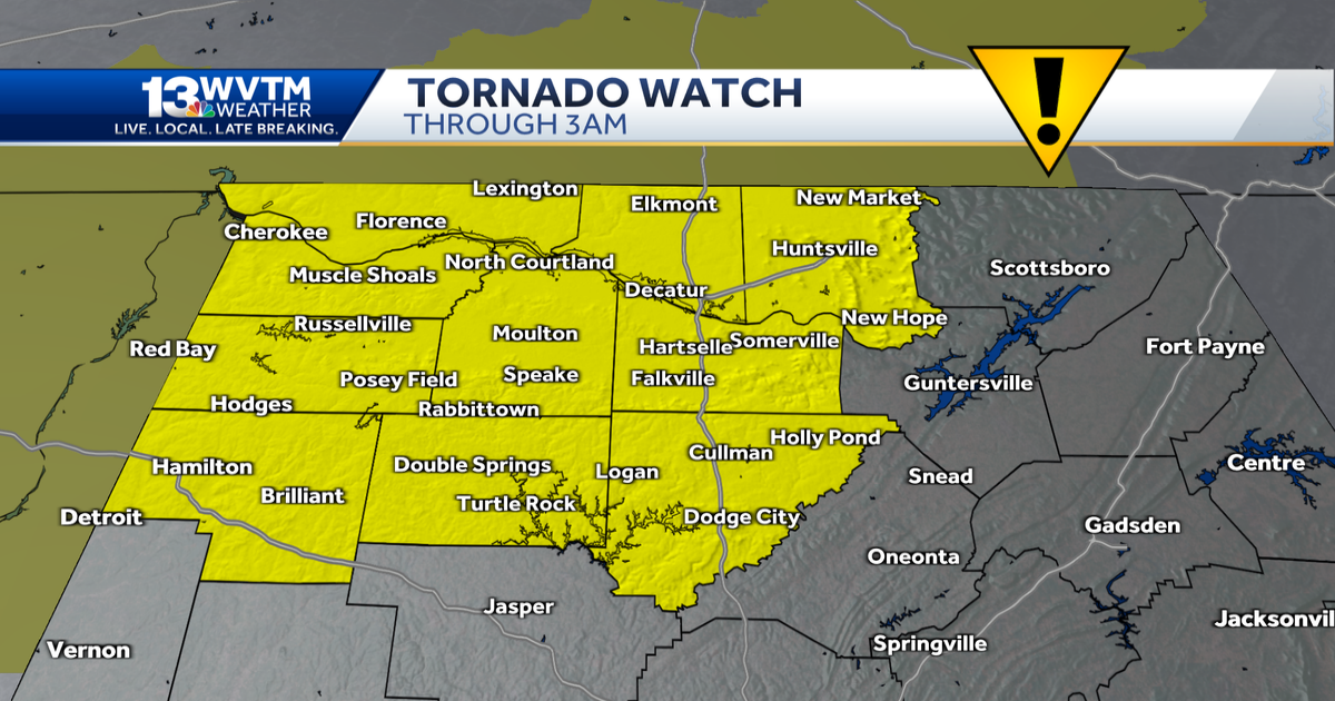
CURRENT WATCHES & WARNINGS

The National Weather Service (NWS) placed a flood watch for North and Central Alabama through Monday evening.

NWS also issued a tornado watch for Colbert, Lauderdale, Winston, Marion, Cullman, Madison, Morgan, Limestone and Franklin counties until 3 a.m. A new tornado watch could be extended into Central Alabama later tonight.

NEWEST TIMELINE:
The newest data available sets the timeline for Alabama’s strongest storms like this:
- 11 p.m. to 8 a.m. Sunday: Lauderdale, Colbert, Lawrence, Limestone, Madison, Franklin, Marion, Winston, Cullman, Walker, Fayette, Lamar, Pickens, and north Tuscaloosa counties.
- 6 a.m. to noon Sunday: Jefferson, Shelby, Greene, Hale, Sumter, St. Clair, Blount, Dekalb, Marshall, Morgan, Bibb and southern Tuscaloosa counties.
- 8 a.m. to 10 p.m. Sunday: Talladega, Tallapoosa, Clay, Coosa, Calhoun, Cherokee, Cleburne, Randolph, Chambers, Lee and Chilton counties.

IMPACTS:
While most storms will sound heavy and loud, there is a limited risk that severe storms, including tornadoes, could develop. The main threat overnight and Sunday will be the slow-moving rain that could lead to flash flooding.

Storm Prediction Center’s Day 1 outlook (valid through 7 a.m. Sunday):

Storm Prediction Center’s Day 2 outlook (begins at 7 a.m. Sunday):

We think 2-3 inches of rain is achievable across many areas. Forecast guidance suggests that some communities north of Interstate 20 could see up to 4 or 5 inches of rainfall Sunday morning.
APRIL COOL SNAP COMING
The normal morning low typically rises from 48 degrees on April 1 to 56 degrees by April 30, but sometimes a cold snap hits the South later than usual. Some call it “Dogwood Winter.”

Regardless of the name, it will be a sharp change to the weather. Temperatures will plunge behind Sunday’s storms, and most of us will end up in the upper 40s and low 50s with a stiff northwest wind by Monday morning.
As clouds slowly move out, Monday afternoon will be cool, with some spots staying below 60 degrees for a high.
Tuesday and Wednesday will feature colder mornings and pleasant afternoons under a mostly sunny sky.

Our usual final frost of the season generally happens in late March to early April, but there appears to be a slim chance of some scattered light frost by Wednesday morning with a clear sky and a light wind.

STAY WEATHER-AWARE
For the latest weather coverage for your area, click here. And stay updated with alerts in the WVTM 13 app. You can download it here.
For the latest Birmingham weather information and Central Alabama’s certified most accurate forecast, watch WVTM 13 News.
Don’t forget to follow us on Facebook, X (formerly Twitter) and Instagram.