NASHVILLE, Tenn. (WSMV) – Multiple rounds of torrential downpours will lead to widespread flooding this weekend. Severe weather is also expected.
Have weather pictures or videos? Share them here.
Download the WSMV 4 First Alert Weather app for iPhone or Android, so you can stay informed on the go and in between newscasts. We share custom videos, plus you can choose to get messages from us on the latest conditions and forecasts.
FIRST ALERT WEATHER DAY — SATURDAY & SUNDAY:
First Alert Weather Days remain in effect for Saturday and Sunday due to expected severe weather and significant flooding that will develop.
A Flood Watch is in effect for most of the area (excluding southeastern Middle Tennessee) until 7 am, Sunday.
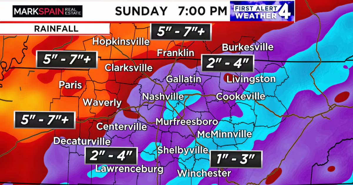
Multiple rounds of soaking downpours are expected off and on through the weekend. The most persistent rain will fall over southern Kentucky, northwest Middle Tennessee, and West Tennessee. There, on top of what has already fallen this week, an additional 5-7″ of rain will be possible, with some areas possibly receiving even more than that. Prepare for widespread, life threatening flash flooding there. Rivers will also continue to rise reaching flood stage in time in most cases.
Farther south and east, rounds of rain are also likely, but they’ll be less persistent. In the greater Nashville area, an additional 2-4″ of rain is likely. Southeastern Middle Tennessee is expected to get 1-3″ of rain by the end of the weekend.
In addition to flooding, isolated severe weather will be possible tonight, primarily over southwest Kentucky.
All of the Midstate needs to be prepared for severe weather on Saturday afternoon and Saturday night as showers and intensifying thunderstorms move through. Damaging wind gusts, hail, and isolated tornadoes will all be possible.
Most of the significant rain will exit the Midstate by early Sunday morning. However, widespread flooding will be in progress near rivers and around creeks and streams, especially those that flash up quickly. Again, the most significant flood problems will be over northwest Middle Tennessee and southern Kentucky.
NEXT WEEK:
Monday looks drier, but cooler with clouds.
Tuesday will be beautiful, cool, and crisp.
Areas of frost are likely Wednesday morning. That afternoon looks lovely.
Isolated late day thundershowers are possible Thursday.
Friday looks seasonable with a high near 70.

Copyright 2025 WSMV. All rights reserved.
