Students on their lunch hour at Leon High School and other high schools in Leon County were brought back inside or held from leaving amid the tornado warning.
“LCS has passed all movement on our campuses due to the current tornado warning. All of our schools have instituted their Tornado Drill Procedures.”
FAMU also sent an alert to students telling them to seek shelter.
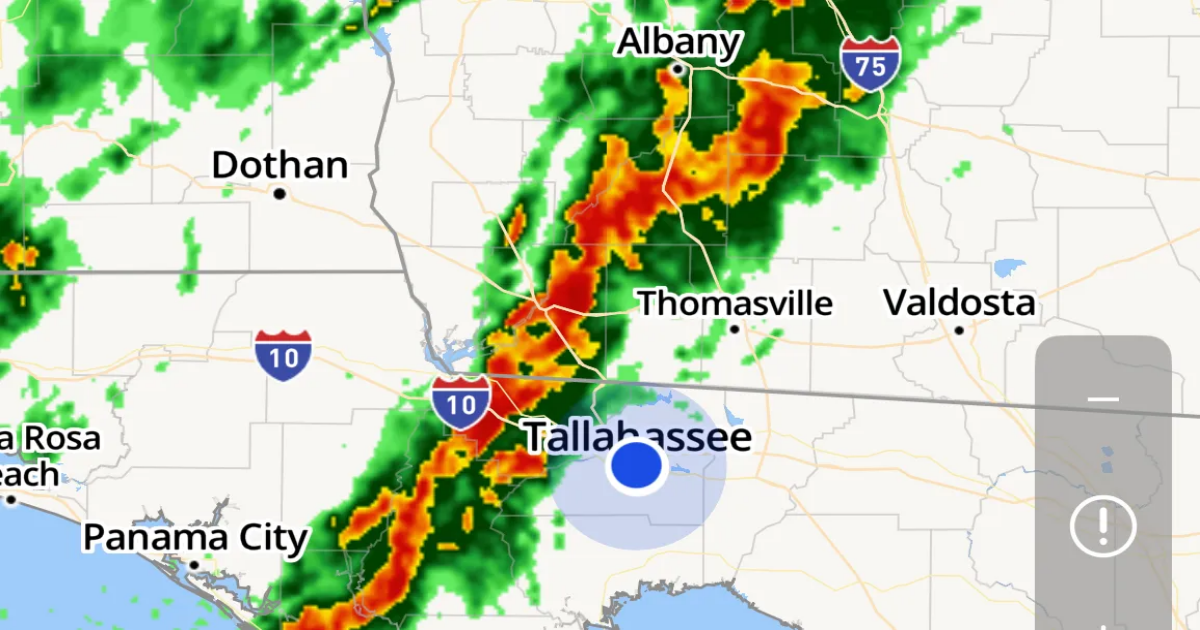
An observed tornado was spotted over Norfleet, just southeast of Midway, at 11:53 a.m. and moving toward Tallahassee and Leon County. The warning is in place for central Leon County until 12:15 p.m.
11:45 a.m.: Tornado warning: Emergency alert goes out in Leon County
Phones buzzed and rang out at about 11:45 as Leon County Emergency Management warned that “tornadoes and damaging winds are possible.
“Mobile home residents should consider seeking shelter in a sturdy building with friends or family… If in a warning, take cover immediately in an interior room away from windows.”
11:35 a.m. Tornado Warning issued for Southwestern Leon County until noon
At 11:30 a.m., a tornado producing storm was located 11 miles southwest of Midway, moving northeast at 35 mph and heading toward Southwestern Leon County.
“Flying debris will be dangerous to those caught without shelter,” according to forecasters. “Mobile homes will be damaged or destroyed. Damage to roofs, windows, and vehicles will occur. Tree damage is likely.”
This tornadic thunderstorm will remain over mainly rural areas of southwestern Leon County.
11:15 a.m.: Severe Thunderstorm Warning issued
A Severe Thunderstorm Warning is in effect until noon for Northwestern Wakulla County, Southeastern Gadsden County, East Central Liberty County and Southwestern Leon County.
“At 11:10 AM EDT, severe thunderstorms were located along a line extending from 11 miles southwest of Midway to 22 miles east of Stonemill Creek, moving northeast at 35 mph.”
A severe thunderstorm warning was also issued for Eastpoint, Carabelle and Apalachicola.
Forecasters say the storms pack 60 mph wind gusts that could cause damage to roofs, siding and trees.
At the same time, a tornado warning has gone up for a portion of Thomas County in south Georgia. The tornado was listed as observed rather than radar indicated.
10:15 a.m.: Tallahassee, Big Bend region under a tornado watch
A tornado watch has been issued for parts of Florida, Georgia and South Carolina until 6 p.m. Eastern. The watch, which includes Tallahassee and Franklin, Liberty, Gadsden, Jefferson, Leon, Wakulla, Madison, Taylor and Lafayette counties in Florida, tells residents to be prepared for the possibility of “a couple tornadoes,” isolated hail up to quarter size,” and scattered wind gusts up to 70 mph.
The slow moving line of storms has already sparked radar-indicated tornado warnings in Florida in Jackson County and in southern Georgia counties.
“Severe weather threat still appears generally low, but the risk for an additional brief tornado or two persists,” the Storm Prediction Center wrote in a morning update.
ORIGINAL STORY
Residents across North Florida should prepare for a potentially stormy start to the week, as the National Weather Service in Tallahassee has placed the region under a Level 2 out of 5 “Slight Risk” for severe storms Monday.
The storm system has already led to tornado warnings for parts of Jackson County and counties in Georgia. Alerts for the radar-indicated twisters broke into TV and radio broadcasts Monday morning.
“A line of storms continues trudging eastward,” NWS forecasters wrote on X at 8:30 a.m. Monday. “We’ve seen convection exhibit rotation, velocity surges, and heavy rain. The environment will remain favorable in its path for severe (weather) & flooding as daytime heating raises instability.”
Monday’s threat: Strong storms, a few tornadoes and flooding possible
A line of slow-moving strong thunderstorms over southeast Alabama and the Florida Panhandle will slowly make its way through the area through the rest of today.
The storms could produce “damaging wind gusts” and the possibility of “a few brief tornadoes,” according to forecasters. Locally heavy rain is possible too.
Cold front brings renewed storm activity
The severe threat began Sunday afternoon with a tornado watch for northwest Florida counties.
As a cold front moves through the region, another round of showers and thunderstorms has redeveloped.
“The leading line of thunderstorms is expected to re-intensify over south central Georgia and the Florida Big Bend late morning into the afternoon as instability increases again,” forecasters wrote. “This will be especially true if enough sunshine breaks through for some daytime heating.”
These storms will also carry a slight risk for severe weather, this time specifically for the Tallahassee area, with damaging winds and brief tornadoes again the primary concerns. Storm coverage is expected to increase gradually through the morning and continue into the early afternoon.
Areas in the Florida Big Bend, including Tallahassee, Perry, and Cross City, will be under the highest risk during the day Monday, while southwest Georgia and the eastern Florida Panhandle will also be affected.
The worst of the weather could hit the Tallahassee area around noon.
Rainfall outlook: much-needed moisture with a chance of flooding
Even behind the front, showers and embedded rumbles of thunder will continue through a good part of the day Monday.
“”The rain isn`t expected to be particularly heavy, but a steady moderate rain will likely persist for several hours after the storms,” forecasters write.
Forecasters say the system is also expected to bring “beneficial rains,” with widespread totals of 1 to 2 inches likely. Some areas in southeast Alabama could see 3 to 5 inches, which could help ease ongoing dry conditions in that area.
With the slow eastward progress of showers and storms, there could be localized flood concerns on Monday as well. Though the National Weather Service’s storm prediction center says the area has only a 5% chance of seeing excessive rainfall.