CNN —
An unusually powerful March storm is trekking across the country with a wide range of hazards from strong winds that could set off blizzard conditions and dust storms to severe thunderstorms that could produce tornadoes.
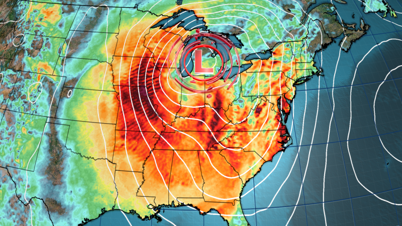
The disruptive storm was building over the Rockies early Monday but will strengthen and expand over much of the central US by Tuesday morning, firing up severe thunderstorms on its southern side and wintry weather to its north.
It’s the first big test for the National Oceanic and Atmospheric Administration and its National Weather Service that’s staffing was slashed by the Trump administration – cuts scientists say will have dangerous consequences for the safety of the American public. Around 800 employees were laid off across NOAA last week.
The storm will get even stronger from there, and could reach “near record strength for March” as it tracks east through the eastern half of the US Wednesday and into Thursday, according to the Weather Prediction Center.
Here’s what to expect each day:
Wind speeds will increase Monday – especially from the afternoon on – in the Rockies and parts of the Plains. These winds could reach 60 mph and be potent enough to knock out power or cause localized damage on their own, but other risks will escalate alongside them.
A level 3 of 3 extremely critical fire weather risk is in place in parts of eastern New Mexico and western Texas as winds blow over very dry land, according to the Storm Prediction Center.
Any spark could quickly turn into a rapidly spreading inferno in these conditions.
Texas Gov. Greg Abbott has directed state emergency personnel to prepare for the possible double whammy of critical fire risk and severe storms. Several state agencies are on standby and have prepared to deploy firefighting and storm rescue teams, including more than 200 firefighting personnel, National Guard helicopters, rescue boats, and additional ambulances and medics, the governor’s office said.
Strong winds and dry land will also combine to create areas of blowing dust that could make it difficult to see and travel hazardous, according to the National Weather Service in Albuquerque, New Mexico.
A dangerous dust storm in southern New Mexico shut down at least two interstates in the area after it began late in the morning. Video from a truck driver on Interstate 10 on Monday shows a multi-vehicle crash amid a hazy dust storm near the city of Deming.
Thunderstorms will roar to life in the evening and overnight from Texas to Kansas. These storms will start a prolonged, widespread threat for damaging wind gusts, hail and tornadoes over the southern US.
Powerful wind gusts and hail will be the main threats when storms first form late Monday, but the tornado threat will increase overnight while individual storms start to congeal into an expansive line.
Severe thunderstorms capable of damaging wind gusts, hail and tornadoes will be ongoing Tuesday morning in parts of the Plains.
The Dallas-Fort Worth metroplex could have powerful storms roar through around sunrise, but dangerous thunderstorms will get another boost from the atmosphere as they cross through the Mississippi Valley by the afternoon.
A level 3 of 5 risk of severe thunderstorms covers large portions of Louisiana, Arkansas and Mississippi, according to the SPC. It’s in this area that the threat for tornadoes is greatest.
Strong tornadoes – rated EF2 or higher– are possible, multiple National Weather Service offices in the region warned Monday.
Tornadoes aren’t the only thing that can unleash serious damage; wind gusts in excess of 70 mph are also possible, the National Weather Service in Jackson, Mississippi, warned.
Severe thunderstorms and strong winds outside of the storms are likely in the New Orleans area Tuesday as the region celebrates Mardi Gras. Some area celebrations were canceled due to the anticipated hazardous weather.
All parades set to kick off Tuesday in Louisiana’s Jefferson Parish – which is part of the greater New Orleans area were canceled.
Two of New Orleans’ most popular parades, Zulu and Rex, will kick off earlier in the morning and run shorter routes in an attempt to avoid the severe weather, police superintendent Anne Kirkpatrick said. The parades’ accompanying truck floats and marchers have been canceled.
The Zulu and Rex parades could still be canceled if the storm system becomes more severe, Kirkpatrick said. Meanwhile, officials are racing to secure loose barriers, portable toilets and other items that could become dangerous projectiles in strong winds.
“We are a city of Carnival. We’re known worldwide for that. You don’t just cancel that easily,” Kirkpatrick said in a Monday news conference. But, she added, “Public safety will always be number one.”
Severe thunderstorms will reach more of the Southeast by the evening and continue overnight. Storms could lose some punch during this time after peaking in strength during the daylight hours, but damaging wind gusts and a few tornadoes are still possible.
Snow and strong winds will pummel parts of the Plains while severe thunderstorms rage farther south.
A few inches of snow will stretch from the Rockies through Nebraska and South Dakota and into parts of the Midwest into Tuesday night. The snow totals alone won’t be a problem for the impacted areas, but add wind gusts in excess of 60 mph and now you’ve a recipe for blizzard conditions.
Blowing snow could drop visibility in the area to near-zero, with whiteout conditions for an extended time.
“Whiteout conditions are expected and will make travel treacherous and potentially life-threatening,” the National Weather Service in North Platte, Nebraska, warned. “The hazardous conditions could impact the Tuesday morning and evening commutes.”
Heavy rain and strong winds are also possible where it isn’t cold enough to snow in parts of the Midwest. This combination could bring down trees and power lines and cause issues for travel on the ground and in the air.
The wide-reaching storm will hit the East Coast Wednesday.
More than 24 million people from Georgia to Pennsylvania and New Jersey – including Washington, DC and Baltimore – are under a level 2 of 5 risk of severe thunderstorms, according to the SPC. Damaging wind gusts and a few tornadoes are possible within these storms.
![]()
Heavy rain and strong winds will impact much of the Northeast while the storm creates blizzard conditions in parts of the Midwest.
Wind gusts of 40 mph or more could occur over much of the eastern half of the US throughout the day.
These winds could wreak havoc on air travel, especially with hubs in Chicago and the New York City area impacted. Power outages could also impact more than a dozen states.
Much of the storm’s precipitation will come to an end in the US Thursday, but gusty winds will persist in its wake.
CNN’s Elizabeth Wolfe and Zenebou Sylla contributed to this report.