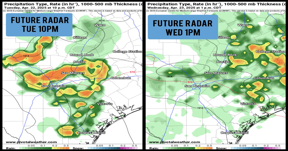
Shown is the potential future radar at 10 p.m. Tuesday (left), as well as 1 p.m. Wednesday (right), according to the ECMWF weather model.
Pivotal Weather
Much of South Texas picked up some beneficial rainfall Sunday morning, as a weak cold front sent line of thunderstorms through the area. Even so, the region is still under exceptional drought conditions, according to the latest update from the U.S. Drought Monitor.
San Antonio has recorded eight consecutive months with below average rainfall, and we’re on track to extend that streak to nine months here in April. However, a major change to the weather pattern is expected in the upcoming week, and it’s likely to bring daily chances of thunderstorms with the potential of significant rainfall. Here’s how the week could play out.
Shown is the current U.S. Drought Monitor, which shows exceptional drought across San Antonio and the Hill Country,
National Drought Mitigation Center
Before the storms arrive later this week, relatively quiet weather is expected for your Monday. Morning temperatures will be quite cool across South Texas, with lows expected to drop into the upper 50s to near 60 degrees in San Antonio. Temperatures will be several degrees cooler in the Hill Country, as lows fall to the low 50s across Kerrville and Fredericksburg.
Article continues below this ad
Skies will be mostly sunny throughout the day, allowing for temps to rise very quickly. San Antonio will hit 80 degrees by noon, continuing to rise to the upper 80s to near 90 degrees by late afternoon. A few rain showers are possible toward the coast, but San Antonio is likely to stay dry throughout the day.
Shown are expected high temperatures across Central and South Texas on Monday.
Pivotal Weather
Starting Tuesday and through the end of the week, high moisture levels are expected to continually stream in from the Gulf. At the same time, several weak atmospheric disturbances will move in from the west each day. Together, these features will cause daily 40 to 60% rain chances from at least Tuesday through Thursday. Isolated storms may also be possible on Friday.
Rain is not expected to last all day. Rather, there will be long stretches of dry conditions, interrupted by brief periods of moderate to heavy rainfall.
Article continues below this ad
With high moisture and instability also in place, there is some potential that the strongest storms could produce large hail and damaging winds. However, a severe weather outbreak is not expected.
The National Blend of Models shows that the San Antonio area can expect between 0.5 and 1 inch of rain spread over the next 3 to 4 days. A few isolated locations could see rainfall totals of up to 2 inches or more.
Slightly higher rainfall totals are possible north of the city, while lower rainfall totals are likely as you move south.
Throughout the week, temperatures are likely to remain near to slightly above normal for this time of the year. High temperatures are likely to reach the upper 80s on Tuesday, dropping a few degrees into the low to mid-80s Wednesday and Thursday. Low temperatures will stay mild, hovering in the upper 60s to near 70 degrees.
Article continues below this ad
Dew points are expected to stay in the upper 60s and low 70s throughout the week, which will result in extremely humid conditions during the dry periods when it’s not raining.