Two wildfires are burning in Greenville and Pickens counties in South Carolina and we are working to provide the latest updates on both fires. We are monitoring the Table Rock fire and the Persimmon Ridge Fire around the clock and will provides updates here. CLICK HERE TO SEE THE LATEST EVACUATIONS DUE TO THESE FIRESThursday night update from the South Carolina Forestry Commission:While the Table Rock Fire grew significantly today, the Persimmon Ridge Fire saw only modest expansion. The weather conditions that created such dramatic fire activity yesterday were much milder today, allowing crews to strengthen firebreaks along key expanses of both fires.No new calls for evacuations were necessary, although existing evacuations remain in place for the same areas east of the Table Rock Fire that were announced yesterday.Weather conditions tomorrow are a concern for increased fire activity, as relative humidity is expected to fall to 23%, and wind gusts could reach nearly 30 mph.A complex incident management team (CIMT) has been shadowing with existing incident command staff all day to ensure a smooth transition tomorrow and throughout the next few weeks as the overall response effort grows.Aviation support was particularly strong today, as one very large air tanker (VLAT) and four LATs dropped retardant on the northern edge of the fire. SLED and SCNG helicopters also dropped water on both fires today, as did the Forestry Commission’s contracted single-engine air tankers (SEATs). It is interesting to note that today was the first drop by a VLAT in South Carolina history.A video sent to WYFF News 4 by Paul Robert Fernander shows that VLAT dropping fire retardant on the wildfire in Table Rock.Officials remind people that it is illegal to fly drones into wildfire areas. There are FAA restrictions when drones are up in an area where helicopters and small planes have clearance.TABLE ROCK FIRE:According to infrared data obtained from a surveillance flight at 4:30 p.m., the Table Rock Fire is now estimated to be 8,679 acres, growing almost exclusively on the northern and western sides of the fire. The fire burned up to the North Carolina state line in several different places.The containment lines on the eastern side of the fire are holding very well so far, as are those on the south, which were fortified by burnouts in and around Table Rock State Park. The eastern containment is particularly good news because so many homes lie beyond the existing firebreaks. Crews will continue strengthening these lines in the coming days.PERSIMMON RIDGE FIRE:The Persimmon Ridge Fire grew to 1,992 acres today, but with most of the additional acreage the result of burnouts that crews were able to conduct between existing firebreaks and the active fire.Tomorrow firefighters hope to complete burnouts of existing unburned areas and focus on improving and holding existing firebreaks.Thursday evening update from the South Carolina Forestry Commission:As of 7:30 p.m., the Table Rock Wildfire is 8679 acres in size at 0% containment.As of 7:30 p.m., the Persimmon Ridge Wildfire is 1992 acres in size at 0% containment.This brings the Table Rock complex wildfires to a combined total of 10,671 acres in size.The 2016 Pinnacle Mountain Fire grew to 10,623 acres in Pickens County. This fire was the largest and costliest wildfire recorded in Upstate history.Thursday afternoon information from United Way of Pickens County: *Help us spread the word.* PICKENS COUNTY RESIDENTS: If you have been displaced by the ongoing fires, please dial 2-1-1 (1-866-892-9211) to learn about the Airbnb Emergency Stay program. Please note this temporary service is only available for Pickens County, SC residents displaced by the current fires. You must meet the eligibility criteria to qualify.Thursday morning update from Greenville County Emergency Management: Evacuations continue for parts of Greenville and Pickens CountiesSpecifically for residents of Oil Camp Creek Road, east to River Falls Road, south to Highway 11, and west to West Gate Road. More than 1400 structures have been evacuated so far. There have been no damages to homes. Crews are monitoring wind gusts, which are not expected to be as strong as in previous days but could still reach 10-15 mph. Officials are continually working to mitigate and contain the fires in the area. Evacuation Shelter: Marietta First Baptist Church (2936 Geer Hwy, Marietta SC 29661)For additional information about evacuations, please call the Table Rock Complex Information Line at (864) 467-3428 is open from 7 a.m. to 7 p.m.Thursday morning update from Pickens County: We currently have an average of 400 first responders working the Table Rock Complex Fire. We would like to open back up the request for citizen donations consisting of the list below:Gold BondMole SkinSafety Glasses/GogglesBandanasDuct TapeSuper GlueMouthwash (Travel Size)Dude WipesBrown Lunch Bags (#12)Little Debbie CakesNapkinsProtein Rich SnacksEye DropsNasal SprayDry Mouth LozengesLiquid IV/Electrolyte Packets Please take ALL donations to the MARKET AT THE MILL. They will be open for donations Wednesday-Saturday from 8:00am-4:00pm. Signs will be posted to direct you to the drop off location.Thursday morning update from SC Forestry Commission: Doug Wood with the SC Forestry Commission he said that the last measured acres burned was 4,556 at Table Rock and 1,553 at Persimmon Ridge. However, he mentioned that as soon as the infrared flight made this assessment (2pm yesterday), winds started gusting and fire crew saw the fire grow. So these fires are larger than last reported, and they anticipate updating those numbers later today.Thursday morning road closure: Highway 11 between West Gate and Pumpkintown is closed to allow unobstructed traffic for emergency vehicles working the fire. The detour route is pictured below. Traffic will be routed off from West Gate to Hickory Hollow Road and from the north at Highway 11 and Highway 8. This will connect to Highway 288 and bring you back out to continue travel on Highway 11. Thank you in advance for your cooperation as our responders work to get water and equipment to needed locations as quickly as possible.Thursday morning weather update: Wednesday night update:As of 10 p.m., the South Carolina Forestry Commission reports the Table Rock Wildfire has grown to 4556 acres in size with 0% containment.As of 10 p.m., the South Carolina Forestry Commission reports the Persimmon Ridge Wildfire has grown to 1553 acres in size with 0% containment.Wednesday evening update:The South Carolina Department of Environmental Services (SCDES) has issued an Air Quality Alert for fine particulates for:All of Pickens and Oconee Counties, and Northern Portions of Greenville and Spartanburg Counties in South Carolina until 12 p.m. (noon) on Thursday, March 27th. An Air Quality Alert means that the fine particulate concentrations within the specified areas may approach or exceed unhealthy standards due to local wildfire smoke.Mountainous Portions of Greenville County in South Carolina until 11:59 p.m. on Thursday, March 27th. An Air Quality Alert means that the fine particulate concentrations within the specified areas may approach or exceed unhealthy standards due to local wildfire smoke.Winds will turn out of the north-northeast across the mountainous terrain of South Carolina this evening. This is expected to push smoke from the Table Rock wildfire in Pickens County and the Persimmon Ridge wildfire in Greenville County southward into parts of the Upstate. As winds become light and variable across the foothills late tonight, stable conditions will enhance the noticeability of smoke, especially for locations along and north of a line from Clemson to Travelers Rest. Light winds will pick up out of the south-southwest by midday Thursday, which will disperse and transport the smoke into the mountainous portion of Greenville County and North Carolina by early afternoon Thursday.SCDES recommends that individuals with respiratory health issues limit time spent outdoors and/or move all activities indoors to avoid the smoke or fine particulates. Keep windows and doors closed. Run an air conditioner if you have one but keep the fresh-air intake closed and the filter clean to prevent outdoor smoke and fine particulates from getting inside. Please note that locations closest to the wildfire activity are more likely to experience smoke at any given time. Anytime you see or smell smoke, take necessary precautions.Wednesday afternoon update:Mandatory evacuations in Transylvania County: A curfew has been placed from 8 p.m. to 8 a.m. for southern Transylvania County.It has been determined that an immediate mandatory evacuation of the area covering on the south side of East Fork Rd from Glady Fork Rd intersection to the intersection of East Fork Rd and Greenville Hwy and then turning right (south) on Greenville Hwy (Hwy 276S) and covering the area on the west side of Greenville Hwy all the way to South Carolina.A shelter for evacuees is open at the Transylvania County Recreation Center at 1078 Ecusta Road.Mandatory evacuations extended: Affected roads:Ashtabula RdAsia Li LnAudies Camp RdBack Park RdBethany Cove DrBethel TerBetween the Lakes RdBird Song TrlBlue Mountain WayBluff Ridge RdBobcat DrBridle DrBurgess Gap RdBusted Rock RdCaesars Head HwyChaney Hill RdCherry Blossom LnChief Outacite LnCisson Ridge RdCold Mountain ViewCompass Rose RdCougar TrlCountry Creek DrCripple Creek RdCrystal Creek CtCunne Shote RdCurts WayDogwood Mountain RdDry Lake RdDuckwood LnElizabeth DrEpworth Hill CirFish Hawk RdGaines Lodge RdGnome Hill LnGreen Acres DrGum Gap Access TrlGum Gap TrlHappy Acres RdHardin RdHardwood LnHatchery LnHemlock LnHummingbird TerHunters DrHwy 11Jane’s LnKalijah LnLakeside Shelter RdLedge RdLifeguard LnLocust RdgLodge View RdLynne WayMary Fraser WayMastes Valley LnMisty Mountain WayMohawk DrMulligan Ford Hill RdOld Chimney LnPinnacle Pavilion RdPleasant Grove RdPrayer Mountain RdPumpkin LnPumpkin Mountain RdRainfall CtRaven Cliff RdRaven CtRescue Access RdRidge Springs RdRiver Bluff RdRiver RdRock Cliffe TrlRockcrest RdRockcrest RdgRockview CtRocky RdS Saluda RdSaluda Hill RdSaluda Shore DrScenic CirShepherd Springs DrShop RdState Line RdT R Campground RdTable Rock State Park RdTrinity TrlTurkey Mountain RdTuscarora LoopUnnamed RdWalker Creek DrWayside DrWeaver Creek TrlWesley Meadow LnWest Gate RdWhite Oaks LnWild Brook DrWinding TrlWindward CtWotawok TrlYesterday’s mandatory evacuation is still in effect. Do not return home.Wednesday morning latest from Greenville County Emergency Management: SCDOT has CLOSED Geer Hwy (US 276) in BOTH directions from Echo Dr. Ext. to SC Hwy 8 due to the Table Rock Complex fires.If you are affected by the Table Rock or Persimmon Ridge Fires, also known as the Table Rock Complex, evacuation information is AVAILABLE by calling 864-467-3428. Both fires are growing due to dry air and gusty winds. Wednesday morning latest from South Carolina Forestry Commission: Extreme fire behavior on both incidents Tuesday prompted immediate mandatory evacuations in Greenville and Pickens counties and led to significant expansion of both fires’ perimeters.The evacuation shelter for all affected residents is Marietta First Baptist Church at 2936 Geer Hwy, Marietta SC 29661). All roads in both counties are listed on the South Carolina Forestry Commission’s Facebook page at https://www.facebook.com/ForestryCommish/Incident command staff has ordered a complex incident management team (CIMT) to join firefighters and other cooperator personnel in the ongoing effort to suppress the Table Rock Fire and Persimmon Ridge Fire. The CIMT is scheduled to arrive tomorrow, shadow with current IMT personnel Thursday and integrate to form a larger command team by Friday. Incident officials also have ordered eight 20-person hand crews to assist with constructing firelines well outside of originally planned firebreaks. While good progress was made on strengthening firebreaks on some portions of both fires earlier in the day, wind gusts dramatically increased fire activity later in the afternoon, resulting in greater, visible fire intensity and much more smoke. The abundance of downed timber from Hurricane Helene remains dry from the lack of significant rain, contributing greatly to the extreme fire behavior today as well. The weather forecast overnight and tomorrow remains concerning, with wind gusts expected to reach around 30 mph tonight, minimum 20% relative humidity Wednesday and periods of windy gusts throughout the day.• Multiple aircraft dropped water and/or retardant on both fires throughout the day (see detail on each fire below).TABLE ROCK FIRE: Despite very good progress fortifying containment lines on the eastern edge of the fire, including a burnout on the northeastern perimeter that otherwise prevented further spread eastward, the Table Rock Fire expanded greatly in the other direction today. The Table Rock Fire is now estimated to be 2, 293 acres. The Table Rock Fire, whose northern edge yesterday was just south of Table Rock Reservoir, essentially burned westward along the forested watershed and eventually back east, halfway around the lake’s northern perimeter. The fire is estimated to have burnt all the way through the southern slopes of Rocky Mountain and Buzzard Mountain, eventually reaching Brushy Knob at last report. Containment lines on the southern portion of the fire were connected by hand crews today, working in steep, littered terrain where heavy equipment is not able to operate. A burnout of this southern section was successful in removing remaining fuels between the firebreaks and the active fire. Two SCNG Black Hawk helicopters dropped water on the fire throughout the day. As fire activity increased in the afternoon, a SLED helicopter and two SCNG Chinooks moved to the Table Rock Fire to assist with additional water drops.PERSIMMON RIDGE FIRE: The Persimmon Ridge Fire expanded its eastern, western and southern of its Monday perimeters today, tripling in size to 996 acres, owing to the same conditions that led to the expansion of the Table Rock Fire. Today two large air tankers (LATs) began making multiple fire retardant drops on the Persimmon Ridge Fire around 2:40 p.m. to help slow the fire’s spread if it jumps the established firelines or continues to spread west and/or south. The first several drops were made along the northern perimeter, along Oil Camp Creek Road, and the western perimeter. Drops continued throughout the afternoon along the other edges of the fire in an intensive effort to contain the fire in a “box” ringed with retardant. LATs can carry between 2,000 to 4,000 gallons of retardant, which alter the way the fire burns, primarily by decreasing fire intensity and slowing its spread. They contain a combination of retardant salts (typically fertilizers) and water that aid in the uniform dispersal of the chemical over the target area. Two SCNG Chinook helicopters also dropped water on the fire, dipping from nearby lakes, before the LATs arrived to drop retardant.PARTNER UPDATES: Greenville and Pickens County Emergency Management services. Both Greenville and Pickens County Emergency Management services rapidly coordinated the simultaneous evacuations, shelter accommodations and wireless emergency alert (WEA) notifications that were sent to residents in the affected areas. SC State Fire: SC State fire has ordered 20 engines and 10 brush trucks for structure protection due to the new fire growth/threat and evacuations. This will add to their existing presence of six engine companies, three battalion chiefs and four brush trucks.South Carolina Forestry CommissionREMINDER ABOUT STATEWIDE BURNING BAN: A statewide burning ban issued Friday, March 21 remains in effect. A State Forester’s Burning Ban prohibits all outdoor burning, including yard debris burning, prescribed burning, campfires, bonfires and other recreational fires in all unincorporated areas of the state. The ban is remaining in place for several reasons. Fire danger will be elevated over the next several days as most of the state is forecast to have low relative humidities and higher-than-normal winds, coupled with drying fuels from a lack of significant rain. It also helps ease the strain on statewide firefighting resources with so many personnel from the Forestry Commission and local fire departments committed to the Table Rock Complex. Officials will reevaluate conditions Thursday.
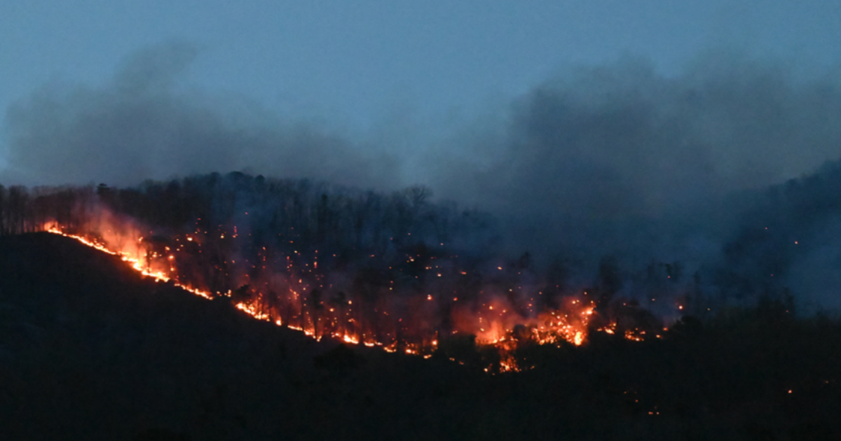
GREENVILLE COUNTY, S.C. —Two wildfires are burning in Greenville and Pickens counties in South Carolina and we are working to provide the latest updates on both fires.
We are monitoring the Table Rock fire and the Persimmon Ridge Fire around the clock and will provides updates here.
CLICK HERE TO SEE THE LATEST EVACUATIONS DUE TO THESE FIRES
Thursday night update from the South Carolina Forestry Commission:
While the Table Rock Fire grew significantly today, the Persimmon Ridge Fire saw only modest expansion. The weather conditions that created such dramatic fire activity yesterday were much milder today, allowing crews to strengthen firebreaks along key expanses of both fires.
No new calls for evacuations were necessary, although existing evacuations remain in place for the same areas east of the Table Rock Fire that were announced yesterday.
Weather conditions tomorrow are a concern for increased fire activity, as relative humidity is expected to fall to 23%, and wind gusts could reach nearly 30 mph.
A complex incident management team (CIMT) has been shadowing with existing incident command staff all day to ensure a smooth transition tomorrow and throughout the next few weeks as the overall response effort grows.
Aviation support was particularly strong today, as one very large air tanker (VLAT) and four LATs dropped retardant on the northern edge of the fire. SLED and SCNG helicopters also dropped water on both fires today, as did the Forestry Commission’s contracted single-engine air tankers (SEATs). It is interesting to note that today was the first drop by a VLAT in South Carolina history.
A video sent to WYFF News 4 by Paul Robert Fernander shows that VLAT dropping fire retardant on the wildfire in Table Rock.
Officials remind people that it is illegal to fly drones into wildfire areas. There are FAA restrictions when drones are up in an area where helicopters and small planes have clearance.
TABLE ROCK FIRE:
According to infrared data obtained from a surveillance flight at 4:30 p.m., the Table Rock Fire is now estimated to be 8,679 acres, growing almost exclusively on the northern and western sides of the fire. The fire burned up to the North Carolina state line in several different places.
The containment lines on the eastern side of the fire are holding very well so far, as are those on the south, which were fortified by burnouts in and around Table Rock State Park. The eastern containment is particularly good news because so many homes lie beyond the existing firebreaks. Crews will continue strengthening these lines in the coming days.
PERSIMMON RIDGE FIRE:
The Persimmon Ridge Fire grew to 1,992 acres today, but with most of the additional acreage the result of burnouts that crews were able to conduct between existing firebreaks and the active fire.
Tomorrow firefighters hope to complete burnouts of existing unburned areas and focus on improving and holding existing firebreaks.
Thursday evening update from the South Carolina Forestry Commission:
As of 7:30 p.m., the Table Rock Wildfire is 8679 acres in size at 0% containment.
As of 7:30 p.m., the Persimmon Ridge Wildfire is 1992 acres in size at 0% containment.
This brings the Table Rock complex wildfires to a combined total of 10,671 acres in size.
The 2016 Pinnacle Mountain Fire grew to 10,623 acres in Pickens County. This fire was the largest and costliest wildfire recorded in Upstate history.
Thursday afternoon information from United Way of Pickens County:
*Help us spread the word.* PICKENS COUNTY RESIDENTS: If you have been displaced by the ongoing fires, please dial 2-1-1 (1-866-892-9211) to learn about the Airbnb Emergency Stay program. Please note this temporary service is only available for Pickens County, SC residents displaced by the current fires. You must meet the eligibility criteria to qualify.
Thursday morning update from Greenville County Emergency Management:
Evacuations continue for parts of Greenville and Pickens Counties
Specifically for residents of Oil Camp Creek Road, east to River Falls Road, south to Highway 11, and west to West Gate Road. More than 1400 structures have been evacuated so far. There have been no damages to homes. Crews are monitoring wind gusts, which are not expected to be as strong as in previous days but could still reach 10-15 mph. Officials are continually working to mitigate and contain the fires in the area. Evacuation Shelter: Marietta First Baptist Church (2936 Geer Hwy, Marietta SC 29661)For additional information about evacuations, please call the Table Rock Complex Information Line at (864) 467-3428 is open from 7 a.m. to 7 p.m.
Thursday morning update from Pickens County:
We currently have an average of 400 first responders working the Table Rock Complex Fire. We would like to open back up the request for citizen donations consisting of the list below:
- Gold Bond
- Mole Skin
- Safety Glasses/Goggles
- Bandanas
- Duct Tape
- Super Glue
- Mouthwash (Travel Size)
- Dude Wipes
- Brown Lunch Bags (#12)
- Little Debbie Cakes
- Napkins
- Protein Rich Snacks
- Eye Drops
- Nasal Spray
- Dry Mouth Lozenges
- Liquid IV/Electrolyte Packets
Please take ALL donations to the MARKET AT THE MILL. They will be open for donations Wednesday-Saturday from 8:00am-4:00pm. Signs will be posted to direct you to the drop off location.
Thursday morning update from SC Forestry Commission:
Doug Wood with the SC Forestry Commission he said that the last measured acres burned was 4,556 at Table Rock and 1,553 at Persimmon Ridge.
However, he mentioned that as soon as the infrared flight made this assessment (2pm yesterday), winds started gusting and fire crew saw the fire grow. So these fires are larger than last reported, and they anticipate updating those numbers later today.
This content is imported from Facebook. You may be able to find the same content in another format, or you may be able to find more information, at their web site.
Thursday morning road closure:
Highway 11 between West Gate and Pumpkintown is closed to allow unobstructed traffic for emergency vehicles working the fire. The detour route is pictured below. Traffic will be routed off from West Gate to Hickory Hollow Road and from the north at Highway 11 and Highway 8. This will connect to Highway 288 and bring you back out to continue travel on Highway 11. Thank you in advance for your cooperation as our responders work to get water and equipment to needed locations as quickly as possible.
Thursday morning weather update:
Wednesday night update:
As of 10 p.m., the South Carolina Forestry Commission reports the Table Rock Wildfire has grown to 4556 acres in size with 0% containment.
As of 10 p.m., the South Carolina Forestry Commission reports the Persimmon Ridge Wildfire has grown to 1553 acres in size with 0% containment.
Wednesday evening update:
The South Carolina Department of Environmental Services (SCDES) has issued an Air Quality Alert for fine particulates for:
- All of Pickens and Oconee Counties, and Northern Portions of Greenville and Spartanburg Counties in South Carolina until 12 p.m. (noon) on Thursday, March 27th. An Air Quality Alert means that the fine particulate concentrations within the specified areas may approach or exceed unhealthy standards due to local wildfire smoke.
- Mountainous Portions of Greenville County in South Carolina until 11:59 p.m. on Thursday, March 27th. An Air Quality Alert means that the fine particulate concentrations within the specified areas may approach or exceed unhealthy standards due to local wildfire smoke.
Winds will turn out of the north-northeast across the mountainous terrain of South Carolina this evening. This is expected to push smoke from the Table Rock wildfire in Pickens County and the Persimmon Ridge wildfire in Greenville County southward into parts of the Upstate. As winds become light and variable across the foothills late tonight, stable conditions will enhance the noticeability of smoke, especially for locations along and north of a line from Clemson to Travelers Rest. Light winds will pick up out of the south-southwest by midday Thursday, which will disperse and transport the smoke into the mountainous portion of Greenville County and North Carolina by early afternoon Thursday.
SCDES recommends that individuals with respiratory health issues limit time spent outdoors and/or move all activities indoors to avoid the smoke or fine particulates. Keep windows and doors closed. Run an air conditioner if you have one but keep the fresh-air intake closed and the filter clean to prevent outdoor smoke and fine particulates from getting inside. Please note that locations closest to the wildfire activity are more likely to experience smoke at any given time. Anytime you see or smell smoke, take necessary precautions.
Wednesday afternoon update:
Mandatory evacuations in Transylvania County:
A curfew has been placed from 8 p.m. to 8 a.m. for southern Transylvania County.
It has been determined that an immediate mandatory evacuation of the area covering on the south side of East Fork Rd from Glady Fork Rd intersection to the intersection of East Fork Rd and Greenville Hwy and then turning right (south) on Greenville Hwy (Hwy 276S) and covering the area on the west side of Greenville Hwy all the way to South Carolina.
A shelter for evacuees is open at the Transylvania County Recreation Center at 1078 Ecusta Road.
Mandatory evacuations extended:
- Affected roads:
- Ashtabula Rd
- Asia Li Ln
- Audies Camp Rd
- Back Park Rd
- Bethany Cove Dr
- Bethel Ter
- Between the Lakes Rd
- Bird Song Trl
- Blue Mountain Way
- Bluff Ridge Rd
- Bobcat Dr
- Bridle Dr
- Burgess Gap Rd
- Busted Rock Rd
- Caesars Head Hwy
- Chaney Hill Rd
- Cherry Blossom Ln
- Chief Outacite Ln
- Cisson Ridge Rd
- Cold Mountain View
- Compass Rose Rd
- Cougar Trl
- Country Creek Dr
- Cripple Creek Rd
- Crystal Creek Ct
- Cunne Shote Rd
- Curts Way
- Dogwood Mountain Rd
- Dry Lake Rd
- Duckwood Ln
- Elizabeth Dr
- Epworth Hill Cir
- Fish Hawk Rd
- Gaines Lodge Rd
- Gnome Hill Ln
- Green Acres Dr
- Gum Gap Access Trl
- Gum Gap Trl
- Happy Acres Rd
- Hardin Rd
- Hardwood Ln
- Hatchery Ln
- Hemlock Ln
- Hummingbird Ter
- Hunters Dr
- Hwy 11
- Jane’s Ln
- Kalijah Ln
- Lakeside Shelter Rd
- Ledge Rd
- Lifeguard Ln
- Locust Rdg
- Lodge View Rd
- Lynne Way
- Mary Fraser Way
- Mastes Valley Ln
- Misty Mountain Way
- Mohawk Dr
- Mulligan Ford Hill Rd
- Old Chimney Ln
- Pinnacle Pavilion Rd
- Pleasant Grove Rd
- Prayer Mountain Rd
- Pumpkin Ln
- Pumpkin Mountain Rd
- Rainfall Ct
- Raven Cliff Rd
- Raven Ct
- Rescue Access Rd
- Ridge Springs Rd
- River Bluff Rd
- River Rd
- Rock Cliffe Trl
- Rockcrest Rd
- Rockcrest Rdg
- Rockview Ct
- Rocky Rd
- S Saluda Rd
- Saluda Hill Rd
- Saluda Shore Dr
- Scenic Cir
- Shepherd Springs Dr
- Shop Rd
- State Line Rd
- T R Campground Rd
- Table Rock State Park Rd
- Trinity Trl
- Turkey Mountain Rd
- Tuscarora Loop
- Unnamed Rd
- Walker Creek Dr
- Wayside Dr
- Weaver Creek Trl
- Wesley Meadow Ln
- West Gate Rd
- White Oaks Ln
- Wild Brook Dr
- Winding Trl
- Windward Ct
- Wotawok Trl
Yesterday’s mandatory evacuation is still in effect. Do not return home.
Wednesday morning latest from Greenville County Emergency Management:
- SCDOT has CLOSED Geer Hwy (US 276) in BOTH directions from Echo Dr. Ext. to SC Hwy 8 due to the Table Rock Complex fires.
- If you are affected by the Table Rock or Persimmon Ridge Fires, also known as the Table Rock Complex, evacuation information is AVAILABLE by calling 864-467-3428. Both fires are growing due to dry air and gusty winds.
Wednesday morning latest from South Carolina Forestry Commission:
Extreme fire behavior on both incidents Tuesday prompted immediate mandatory evacuations in Greenville and Pickens counties and led to significant expansion of both fires’ perimeters.
The evacuation shelter for all affected residents is Marietta First Baptist Church at 2936 Geer Hwy, Marietta SC 29661). All roads in both counties are listed on the South Carolina Forestry Commission’s Facebook page at https://www.facebook.com/ForestryCommish/
Incident command staff has ordered a complex incident management team (CIMT) to join firefighters and other cooperator personnel in the ongoing effort to suppress the Table Rock Fire and Persimmon Ridge Fire. The CIMT is scheduled to arrive tomorrow, shadow with current IMT personnel Thursday and integrate to form a larger command team by Friday. Incident officials also have ordered eight 20-person hand crews to assist with constructing firelines well outside of originally planned firebreaks. While good progress was made on strengthening firebreaks on some portions of both fires earlier in the day, wind gusts dramatically increased fire activity later in the afternoon, resulting in greater, visible fire intensity and much more smoke. The abundance of downed timber from Hurricane Helene remains dry from the lack of significant rain, contributing greatly to the extreme fire behavior today as well. The weather forecast overnight and tomorrow remains concerning, with wind gusts expected to reach around 30 mph tonight, minimum 20% relative humidity Wednesday and periods of windy gusts throughout the day.• Multiple aircraft dropped water and/or retardant on both fires throughout the day (see detail on each fire below).
TABLE ROCK FIRE: Despite very good progress fortifying containment lines on the eastern edge of the fire, including a burnout on the northeastern perimeter that otherwise prevented further spread eastward, the Table Rock Fire expanded greatly in the other direction today. The Table Rock Fire is now estimated to be 2, 293 acres. The Table Rock Fire, whose northern edge yesterday was just south of Table Rock Reservoir, essentially burned westward along the forested watershed and eventually back east, halfway around the lake’s northern perimeter. The fire is estimated to have burnt all the way through the southern slopes of Rocky Mountain and Buzzard Mountain, eventually reaching Brushy Knob at last report. Containment lines on the southern portion of the fire were connected by hand crews today, working in steep, littered terrain where heavy equipment is not able to operate. A burnout of this southern section was successful in removing remaining fuels between the firebreaks and the active fire. Two SCNG Black Hawk helicopters dropped water on the fire throughout the day. As fire activity increased in the afternoon, a SLED helicopter and two SCNG Chinooks moved to the Table Rock Fire to assist with additional water drops.
PERSIMMON RIDGE FIRE: The Persimmon Ridge Fire expanded its eastern, western and southern of its Monday perimeters today, tripling in size to 996 acres, owing to the same conditions that led to the expansion of the Table Rock Fire. Today two large air tankers (LATs) began making multiple fire retardant drops on the Persimmon Ridge Fire around 2:40 p.m. to help slow the fire’s spread if it jumps the established firelines or continues to spread west and/or south. The first several drops were made along the northern perimeter, along Oil Camp Creek Road, and the western perimeter. Drops continued throughout the afternoon along the other edges of the fire in an intensive effort to contain the fire in a “box” ringed with retardant. LATs can carry between 2,000 to 4,000 gallons of retardant, which alter the way the fire burns, primarily by decreasing fire intensity and slowing its spread. They contain a combination of retardant salts (typically fertilizers) and water that aid in the uniform dispersal of the chemical over the target area. Two SCNG Chinook helicopters also dropped water on the fire, dipping from nearby lakes, before the LATs arrived to drop retardant.
PARTNER UPDATES: Greenville and Pickens County Emergency Management services. Both Greenville and Pickens County Emergency Management services rapidly coordinated the simultaneous evacuations, shelter accommodations and wireless emergency alert (WEA) notifications that were sent to residents in the affected areas.
SC State Fire: SC State fire has ordered 20 engines and 10 brush trucks for structure protection due to the new fire growth/threat and evacuations. This will add to their existing presence of six engine companies, three battalion chiefs and four brush trucks.South Carolina Forestry Commission
REMINDER ABOUT STATEWIDE BURNING BAN: A statewide burning ban issued Friday, March 21 remains in effect. A State Forester’s Burning Ban prohibits all outdoor burning, including yard debris burning, prescribed burning, campfires, bonfires and other recreational fires in all unincorporated areas of the state. The ban is remaining in place for several reasons. Fire danger will be elevated over the next several days as most of the state is forecast to have low relative humidities and higher-than-normal winds, coupled with drying fuels from a lack of significant rain. It also helps ease the strain on statewide firefighting resources with so many personnel from the Forestry Commission and local fire departments committed to the Table Rock Complex. Officials will reevaluate conditions Thursday.